You are here: Home > Network List > TA - USArray Transportable Network (new EarthScope stations) Stations List
> Station P27A Ficken Ranch, Kirk, CO, USA > Earthquake Result Viewer
P27A Ficken Ranch, Kirk, CO, USA - Earthquake Result Viewer
| Earthquake location: |
Costa Rica |
| Earthquake latitude/longitude: |
9.2/-84.3 |
| Earthquake time(UTC): |
2010/05/20 (140) 22:16:30 GMT |
| Earthquake Depth: |
21 km |
| Earthquake Magnitude: |
5.6 MB, 5.6 MS, 5.9 MW, 5.9 MW |
| Earthquake Catalog/Contributor: |
WHDF/NEIC |
|
| Network: |
TA USArray Transportable Network (new EarthScope stations) |
| Station: |
P27A Ficken Ranch, Kirk, CO, USA |
| Lat/Lon: |
39.56 N/102.58 W |
| Elevation: |
1286 m |
|
| Distance: |
34.3 deg |
| Az: |
334.529 deg |
| Baz: |
146.692 deg |
| Ray Param: |
0.07777856 |
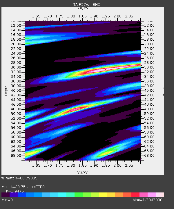
| Estimated Moho Depth: |
30.75 km |
| Estimated Crust Vp/Vs: |
1.95 |
| Assumed Crust Vp: |
6.242 km/s |
| Estimated Crust Vs: |
3.205 km/s |
| Estimated Crust Poisson's Ratio: |
0.32 |
|
| Radial Match: |
88.79835 % |
| Radial Bump: |
281 |
| Transverse Match: |
59.369675 % |
| Transverse Bump: |
358 |
| SOD ConfigId: |
314592 |
| Insert Time: |
2010-09-04 08:30:51.033 +0000 |
| GWidth: |
2.5 |
| Max Bumps: |
400 |
| Tol: |
0.001 |
|
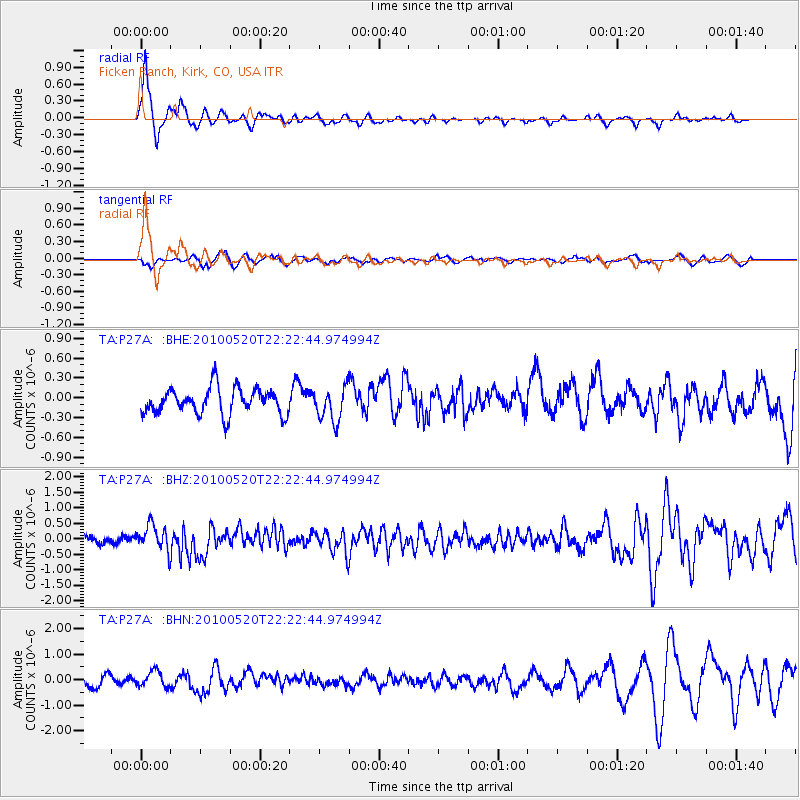
Signal To Noise
| Channel | StoN | STA | LTA |
| TA:P27A: :BHZ:20100520T22:22:44.974994Z | 3.282297 | 4.1292296E-7 | 1.2580306E-7 |
| TA:P27A: :BHN:20100520T22:22:44.974994Z | 1.5696406 | 3.085007E-7 | 1.9654223E-7 |
| TA:P27A: :BHE:20100520T22:22:44.974994Z | 1.2848138 | 2.5158567E-7 | 1.9581489E-7 |
| Arrivals |
| Ps | 5.0 SECOND |
| PpPs | 14 SECOND |
| PsPs/PpSs | 19 SECOND |


