You are here: Home > Network List > TA - USArray Transportable Network (new EarthScope stations) Stations List
> Station T31A Randall Ranch, Ashland, KS, USA > Earthquake Result Viewer
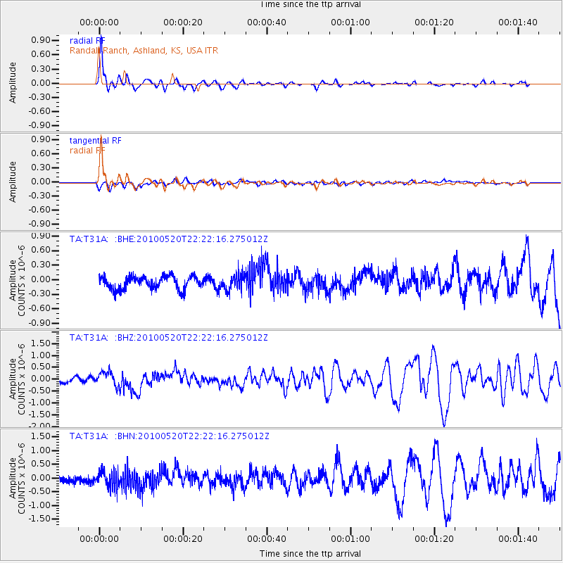
T31A Randall Ranch, Ashland, KS, USA - Earthquake Result Viewer

| Earthquake location: |
Costa Rica |
| Earthquake latitude/longitude: |
9.2/-84.3 |
| Earthquake time(UTC): |
2010/05/20 (140) 22:16:30 GMT |
| Earthquake Depth: |
21 km |
| Earthquake Magnitude: |
5.6 MB, 5.6 MS, 5.9 MW, 5.9 MW |
| Earthquake Catalog/Contributor: |
WHDF/NEIC |
|
| Network: |
TA USArray Transportable Network (new EarthScope stations) |
| Station: |
T31A Randall Ranch, Ashland, KS, USA |
| Lat/Lon: |
37.10 N/99.68 W |
| Elevation: |
564 m |
|
| Distance: |
31.0 deg |
| Az: |
335.714 deg |
| Baz: |
149.483 deg |
| Ray Param: |
0.079163775 |
| Estimated Moho Depth: |
25.0 km |
| Estimated Crust Vp/Vs: |
2.10 |
| Assumed Crust Vp: |
6.426 km/s |
| Estimated Crust Vs: |
3.064 km/s |
| Estimated Crust Poisson's Ratio: |
0.35 |
|
| Radial Match: |
92.323746 % |
| Radial Bump: |
321 |
| Transverse Match: |
52.531902 % |
| Transverse Bump: |
400 |
| SOD ConfigId: |
314592 |
| Insert Time: |
2010-09-04 08:30:56.049 +0000 |
| GWidth: |
2.5 |
| Max Bumps: |
400 |
| Tol: |
0.001 |
|
Signal To Noise
| Channel | StoN | STA | LTA |
| TA:T31A: :BHZ:20100520T22:22:16.275012Z | 2.4879193 | 2.9420912E-7 | 1.1825509E-7 |
| TA:T31A: :BHN:20100520T22:22:16.275012Z | 2.18678 | 2.9441279E-7 | 1.3463301E-7 |
| TA:T31A: :BHE:20100520T22:22:16.275012Z | 1.1780268 | 1.5460094E-7 | 1.312372E-7 |
| Arrivals |
| Ps | 4.6 SECOND |
| PpPs | 11 SECOND |
| PsPs/PpSs | 16 SECOND |


