You are here: Home > Network List > TA - USArray Transportable Network (new EarthScope stations) Stations List
> Station S28A Manter, KS, USA > Earthquake Result Viewer
S28A Manter, KS, USA - Earthquake Result Viewer
| Earthquake location: |
Costa Rica |
| Earthquake latitude/longitude: |
9.2/-84.3 |
| Earthquake time(UTC): |
2010/05/20 (140) 22:16:30 GMT |
| Earthquake Depth: |
21 km |
| Earthquake Magnitude: |
5.6 MB, 5.6 MS, 5.9 MW, 5.9 MW |
| Earthquake Catalog/Contributor: |
WHDF/NEIC |
|
| Network: |
TA USArray Transportable Network (new EarthScope stations) |
| Station: |
S28A Manter, KS, USA |
| Lat/Lon: |
37.59 N/101.90 W |
| Elevation: |
1064 m |
|
| Distance: |
32.4 deg |
| Az: |
333.362 deg |
| Baz: |
146.14 deg |
| Ray Param: |
0.07865216 |
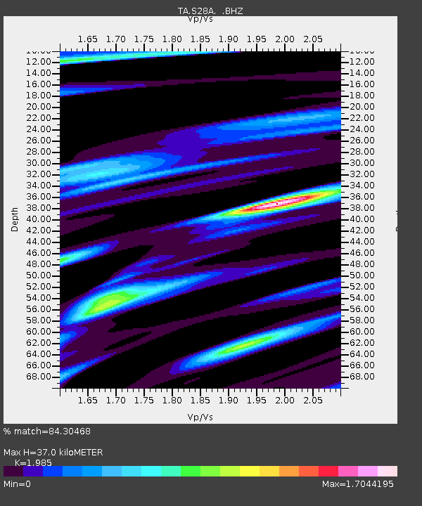
| Estimated Moho Depth: |
37.0 km |
| Estimated Crust Vp/Vs: |
1.99 |
| Assumed Crust Vp: |
6.483 km/s |
| Estimated Crust Vs: |
3.266 km/s |
| Estimated Crust Poisson's Ratio: |
0.33 |
|
| Radial Match: |
84.30468 % |
| Radial Bump: |
400 |
| Transverse Match: |
48.261917 % |
| Transverse Bump: |
400 |
| SOD ConfigId: |
314592 |
| Insert Time: |
2010-09-04 08:31:31.993 +0000 |
| GWidth: |
2.5 |
| Max Bumps: |
400 |
| Tol: |
0.001 |
|
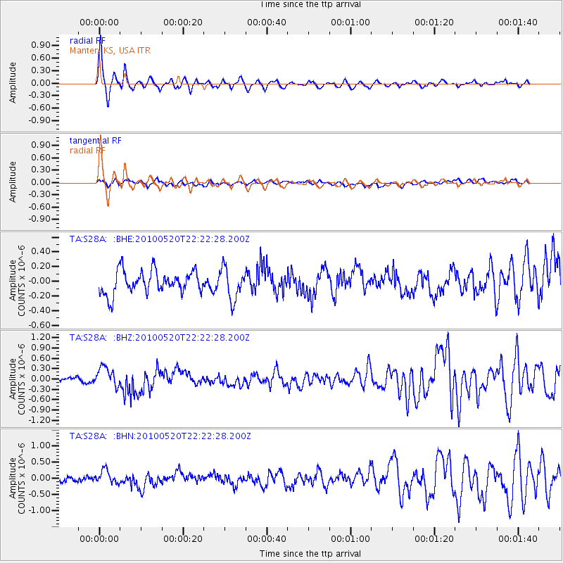
Signal To Noise
| Channel | StoN | STA | LTA |
| TA:S28A: :BHZ:20100520T22:22:28.200Z | 4.0734806 | 2.9504702E-7 | 7.243118E-8 |
| TA:S28A: :BHN:20100520T22:22:28.200Z | 2.3124628 | 2.0482932E-7 | 8.8576265E-8 |
| TA:S28A: :BHE:20100520T22:22:28.200Z | 1.4358692 | 2.2059228E-7 | 1.5362978E-7 |
| Arrivals |
| Ps | 6.0 SECOND |
| PpPs | 16 SECOND |
| PsPs/PpSs | 22 SECOND |


