You are here: Home > Network List > IW - Intermountain West Stations List
> Station MOOW Moose Ponds, Wyoming, USA > Earthquake Result Viewer
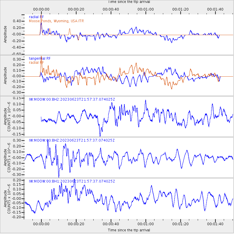
MOOW Moose Ponds, Wyoming, USA - Earthquake Result Viewer
*The percent match for this event was below the threshold and hence no stack was calculated.
| Earthquake location: |
Northern Mid-Atlantic Ridge |
| Earthquake latitude/longitude: |
44.9/-28.1 |
| Earthquake time(UTC): |
2023/06/23 (174) 21:48:25 GMT |
| Earthquake Depth: |
10 km |
| Earthquake Magnitude: |
5.6 Mww |
| Earthquake Catalog/Contributor: |
NEIC PDE/us |
|
| Network: |
IW Intermountain West |
| Station: |
MOOW Moose Ponds, Wyoming, USA |
| Lat/Lon: |
43.75 N/110.74 W |
| Elevation: |
2128 m |
|
| Distance: |
56.6 deg |
| Az: |
300.553 deg |
| Baz: |
57.567 deg |
| Ray Param: |
$rayparam |
*The percent match for this event was below the threshold and hence was not used in the summary stack. |
|
| Radial Match: |
38.89625 % |
| Radial Bump: |
400 |
| Transverse Match: |
39.716892 % |
| Transverse Bump: |
400 |
| SOD ConfigId: |
30536071 |
| Insert Time: |
2023-07-07 22:05:58.757 +0000 |
| GWidth: |
2.5 |
| Max Bumps: |
400 |
| Tol: |
0.001 |
|
Signal To Noise
| Channel | StoN | STA | LTA |
| IW:MOOW:00:BHZ:20230623T21:57:37.074025Z | 3.4139085 | 1.2392394E-7 | 3.6299724E-8 |
| IW:MOOW:00:BH1:20230623T21:57:37.074025Z | 1.2325628 | 4.099688E-8 | 3.3261497E-8 |
| IW:MOOW:00:BH2:20230623T21:57:37.074025Z | 2.178128 | 5.9653196E-8 | 2.738737E-8 |
| Arrivals |
| Ps | |
| PpPs | |
| PsPs/PpSs | |


