You are here: Home > Network List > TA - USArray Transportable Network (new EarthScope stations) Stations List
> Station N32A Stulken Farm, Doniphan, NE, USA > Earthquake Result Viewer
N32A Stulken Farm, Doniphan, NE, USA - Earthquake Result Viewer

| Earthquake location: |
Costa Rica |
| Earthquake latitude/longitude: |
9.2/-84.3 |
| Earthquake time(UTC): |
2010/05/20 (140) 22:16:30 GMT |
| Earthquake Depth: |
21 km |
| Earthquake Magnitude: |
5.6 MB, 5.6 MS, 5.9 MW, 5.9 MW |
| Earthquake Catalog/Contributor: |
WHDF/NEIC |
|
| Network: |
TA USArray Transportable Network (new EarthScope stations) |
| Station: |
N32A Stulken Farm, Doniphan, NE, USA |
| Lat/Lon: |
40.76 N/98.30 W |
| Elevation: |
587 m |
|
| Distance: |
33.8 deg |
| Az: |
340.698 deg |
| Baz: |
154.558 deg |
| Ray Param: |
0.07803755 |
| Estimated Moho Depth: |
56.5 km |
| Estimated Crust Vp/Vs: |
1.62 |
| Assumed Crust Vp: |
6.53 km/s |
| Estimated Crust Vs: |
4.031 km/s |
| Estimated Crust Poisson's Ratio: |
0.19 |
|
| Radial Match: |
95.01736 % |
| Radial Bump: |
320 |
| Transverse Match: |
62.417686 % |
| Transverse Bump: |
400 |
| SOD ConfigId: |
314592 |
| Insert Time: |
2010-09-04 08:38:00.803 +0000 |
| GWidth: |
2.5 |
| Max Bumps: |
400 |
| Tol: |
0.001 |
|
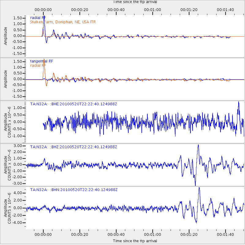
Signal To Noise
| Channel | StoN | STA | LTA |
| TA:N32A: :BHZ:20100520T22:22:40.124988Z | 2.7779899 | 4.6630052E-7 | 1.6785538E-7 |
| TA:N32A: :BHN:20100520T22:22:40.124988Z | 1.9485552 | 4.196473E-7 | 2.1536331E-7 |
| TA:N32A: :BHE:20100520T22:22:40.124988Z | 1.2102565 | 3.5574226E-7 | 2.9393956E-7 |
| Arrivals |
| Ps | 5.9 SECOND |
| PpPs | 21 SECOND |
| PsPs/PpSs | 27 SECOND |


