You are here: Home > Network List > WY - Yellowstone Wyoming Seismic Network Stations List
> Station YHR Hawk's Rest, WY, USA > Earthquake Result Viewer
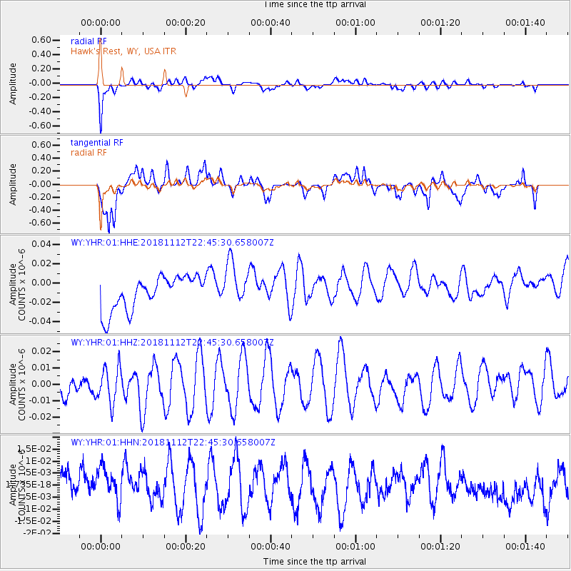
YHR Hawk's Rest, WY, USA - Earthquake Result Viewer
*The percent match for this event was below the threshold and hence no stack was calculated.
| Earthquake location: |
Central East Pacific Rise |
| Earthquake latitude/longitude: |
-3.1/-103.4 |
| Earthquake time(UTC): |
2018/11/12 (316) 22:37:27 GMT |
| Earthquake Depth: |
10 km |
| Earthquake Magnitude: |
5.6 Mww |
| Earthquake Catalog/Contributor: |
NEIC PDE/us |
|
| Network: |
WY Yellowstone Wyoming Seismic Network |
| Station: |
YHR Hawk's Rest, WY, USA |
| Lat/Lon: |
44.11 N/110.08 W |
| Elevation: |
2976 m |
|
| Distance: |
47.4 deg |
| Az: |
353.484 deg |
| Baz: |
170.95 deg |
| Ray Param: |
$rayparam |
*The percent match for this event was below the threshold and hence was not used in the summary stack. |
|
| Radial Match: |
86.7291 % |
| Radial Bump: |
400 |
| Transverse Match: |
65.17544 % |
| Transverse Bump: |
400 |
| SOD ConfigId: |
3131071 |
| Insert Time: |
2018-11-26 22:47:52.259 +0000 |
| GWidth: |
2.5 |
| Max Bumps: |
400 |
| Tol: |
0.001 |
|
Signal To Noise
| Channel | StoN | STA | LTA |
| WY:YHR:01:HHZ:20181112T22:45:30.658007Z | 1.4684114 | 1.1233433E-8 | 7.6500575E-9 |
| WY:YHR:01:HHN:20181112T22:45:30.658007Z | 1.0970937 | 9.015966E-9 | 8.218045E-9 |
| WY:YHR:01:HHE:20181112T22:45:30.658007Z | 1.3250206 | 2.3078666E-8 | 1.7417591E-8 |
| Arrivals |
| Ps | |
| PpPs | |
| PsPs/PpSs | |


