You are here: Home > Network List > AK - Alaska Regional Network Stations List
> Station CCB Clear Creek Butte, AK, USA > Earthquake Result Viewer
CCB Clear Creek Butte, AK, USA - Earthquake Result Viewer
| Earthquake location: |
South Of Tonga Islands |
| Earthquake latitude/longitude: |
-24.0/-175.6 |
| Earthquake time(UTC): |
2023/06/25 (176) 07:16:59 GMT |
| Earthquake Depth: |
7.1 km |
| Earthquake Magnitude: |
6.0 mww |
| Earthquake Catalog/Contributor: |
NEIC PDE/us |
|
| Network: |
AK Alaska Regional Network |
| Station: |
CCB Clear Creek Butte, AK, USA |
| Lat/Lon: |
64.65 N/147.81 W |
| Elevation: |
233 m |
|
| Distance: |
91.0 deg |
| Az: |
11.594 deg |
| Baz: |
205.264 deg |
| Ray Param: |
0.04165815 |
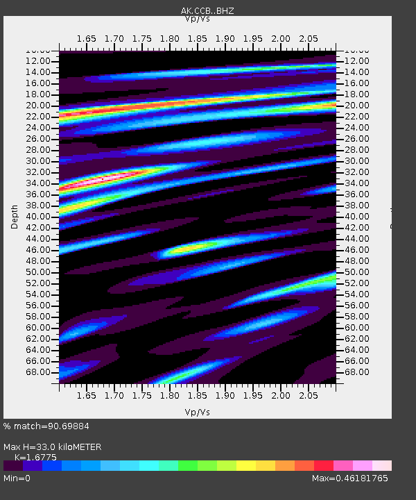
| Estimated Moho Depth: |
33.0 km |
| Estimated Crust Vp/Vs: |
1.68 |
| Assumed Crust Vp: |
6.566 km/s |
| Estimated Crust Vs: |
3.914 km/s |
| Estimated Crust Poisson's Ratio: |
0.22 |
|
| Radial Match: |
90.69884 % |
| Radial Bump: |
400 |
| Transverse Match: |
90.18329 % |
| Transverse Bump: |
400 |
| SOD ConfigId: |
30536071 |
| Insert Time: |
2023-07-09 07:19:26.343 +0000 |
| GWidth: |
2.5 |
| Max Bumps: |
400 |
| Tol: |
0.001 |
|

Signal To Noise
| Channel | StoN | STA | LTA |
| AK:CCB: :BHZ:20230625T07:29:32.588022Z | 5.069503 | 2.3841528E-7 | 4.7029324E-8 |
| AK:CCB: :BHN:20230625T07:29:32.588022Z | 1.703107 | 6.143131E-8 | 3.607014E-8 |
| AK:CCB: :BHE:20230625T07:29:32.588022Z | 2.0456412 | 6.101757E-8 | 2.982809E-8 |
| Arrivals |
| Ps | 3.5 SECOND |
| PpPs | 13 SECOND |
| PsPs/PpSs | 17 SECOND |


