You are here: Home > Network List > AK - Alaska Regional Network Stations List
> Station HIN Hinchinbrook, AK, USA > Earthquake Result Viewer
HIN Hinchinbrook, AK, USA - Earthquake Result Viewer
| Earthquake location: |
South Of Tonga Islands |
| Earthquake latitude/longitude: |
-24.0/-175.6 |
| Earthquake time(UTC): |
2023/06/25 (176) 07:16:59 GMT |
| Earthquake Depth: |
7.1 km |
| Earthquake Magnitude: |
6.0 mww |
| Earthquake Catalog/Contributor: |
NEIC PDE/us |
|
| Network: |
AK Alaska Regional Network |
| Station: |
HIN Hinchinbrook, AK, USA |
| Lat/Lon: |
60.40 N/146.50 W |
| Elevation: |
623 m |
|
| Distance: |
87.4 deg |
| Az: |
13.998 deg |
| Baz: |
206.452 deg |
| Ray Param: |
0.043345824 |
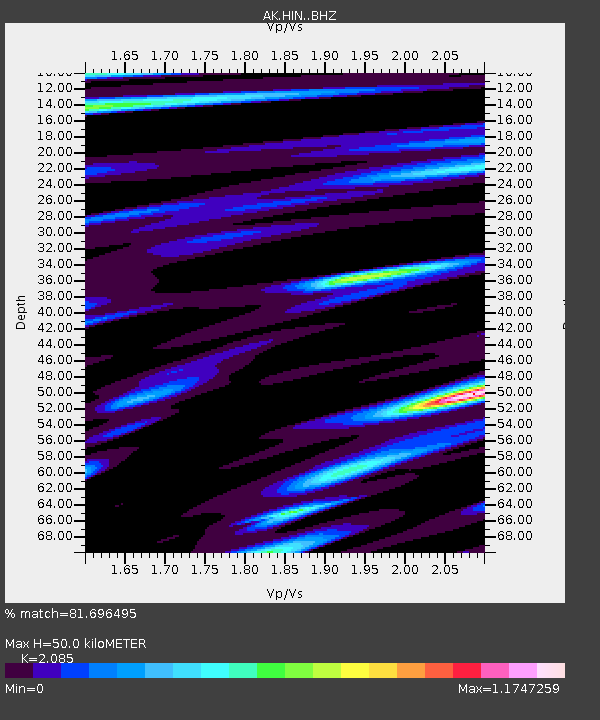
| Estimated Moho Depth: |
50.0 km |
| Estimated Crust Vp/Vs: |
2.09 |
| Assumed Crust Vp: |
6.566 km/s |
| Estimated Crust Vs: |
3.149 km/s |
| Estimated Crust Poisson's Ratio: |
0.35 |
|
| Radial Match: |
81.696495 % |
| Radial Bump: |
400 |
| Transverse Match: |
62.08054 % |
| Transverse Bump: |
400 |
| SOD ConfigId: |
30536071 |
| Insert Time: |
2023-07-09 07:20:30.034 +0000 |
| GWidth: |
2.5 |
| Max Bumps: |
400 |
| Tol: |
0.001 |
|

Signal To Noise
| Channel | StoN | STA | LTA |
| AK:HIN: :BHZ:20230625T07:29:15.826975Z | 1.7310342 | 3.5880612E-7 | 2.0727848E-7 |
| AK:HIN: :BHN:20230625T07:29:15.826975Z | 1.226021 | 2.647174E-7 | 2.1591586E-7 |
| AK:HIN: :BHE:20230625T07:29:15.826975Z | 1.0231316 | 3.0018958E-7 | 2.934027E-7 |
| Arrivals |
| Ps | 8.4 SECOND |
| PpPs | 23 SECOND |
| PsPs/PpSs | 31 SECOND |


