You are here: Home > Network List > AK - Alaska Regional Network Stations List
> Station K27K Chicken, AK, USA > Earthquake Result Viewer
K27K Chicken, AK, USA - Earthquake Result Viewer
| Earthquake location: |
South Of Tonga Islands |
| Earthquake latitude/longitude: |
-24.0/-175.6 |
| Earthquake time(UTC): |
2023/06/25 (176) 07:16:59 GMT |
| Earthquake Depth: |
7.1 km |
| Earthquake Magnitude: |
6.0 mww |
| Earthquake Catalog/Contributor: |
NEIC PDE/us |
|
| Network: |
AK Alaska Regional Network |
| Station: |
K27K Chicken, AK, USA |
| Lat/Lon: |
64.03 N/142.08 W |
| Elevation: |
732 m |
|
| Distance: |
91.6 deg |
| Az: |
14.089 deg |
| Baz: |
210.366 deg |
| Ray Param: |
0.0415861 |
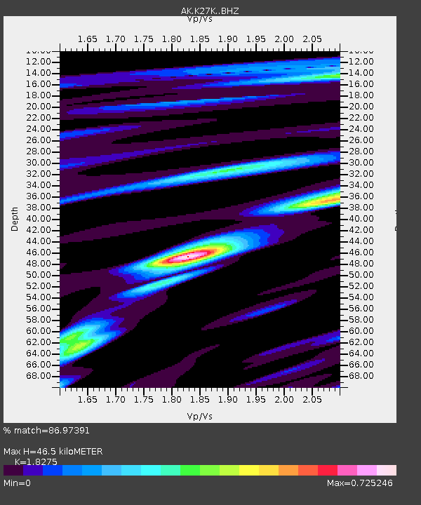
| Estimated Moho Depth: |
46.5 km |
| Estimated Crust Vp/Vs: |
1.83 |
| Assumed Crust Vp: |
6.566 km/s |
| Estimated Crust Vs: |
3.593 km/s |
| Estimated Crust Poisson's Ratio: |
0.29 |
|
| Radial Match: |
86.97391 % |
| Radial Bump: |
400 |
| Transverse Match: |
81.68894 % |
| Transverse Bump: |
400 |
| SOD ConfigId: |
30536071 |
| Insert Time: |
2023-07-09 07:20:49.825 +0000 |
| GWidth: |
2.5 |
| Max Bumps: |
400 |
| Tol: |
0.001 |
|

Signal To Noise
| Channel | StoN | STA | LTA |
| AK:K27K: :BHZ:20230625T07:29:35.440012Z | 3.6914628 | 1.6031802E-7 | 4.3429406E-8 |
| AK:K27K: :BHN:20230625T07:29:35.440012Z | 1.4376994 | 6.000339E-8 | 4.1735696E-8 |
| AK:K27K: :BHE:20230625T07:29:35.440012Z | 0.6768674 | 2.5802677E-8 | 3.8120728E-8 |
| Arrivals |
| Ps | 6.0 SECOND |
| PpPs | 20 SECOND |
| PsPs/PpSs | 26 SECOND |


