You are here: Home > Network List > US - United States National Seismic Network Stations List
> Station WRAK Wrangell Island, Southeastern Alaska, Alaska, USA > Earthquake Result Viewer
WRAK Wrangell Island, Southeastern Alaska, Alaska, USA - Earthquake Result Viewer
| Earthquake location: |
South Of Tonga Islands |
| Earthquake latitude/longitude: |
-24.0/-175.6 |
| Earthquake time(UTC): |
2023/06/25 (176) 07:16:59 GMT |
| Earthquake Depth: |
7.1 km |
| Earthquake Magnitude: |
6.0 mww |
| Earthquake Catalog/Contributor: |
NEIC PDE/us |
|
| Network: |
US United States National Seismic Network |
| Station: |
WRAK Wrangell Island, Southeastern Alaska, Alaska, USA |
| Lat/Lon: |
56.42 N/132.35 W |
| Elevation: |
81 m |
|
| Distance: |
88.1 deg |
| Az: |
22.406 deg |
| Baz: |
218.842 deg |
| Ray Param: |
0.04284814 |
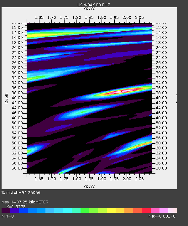
| Estimated Moho Depth: |
37.25 km |
| Estimated Crust Vp/Vs: |
1.98 |
| Assumed Crust Vp: |
6.597 km/s |
| Estimated Crust Vs: |
3.336 km/s |
| Estimated Crust Poisson's Ratio: |
0.33 |
|
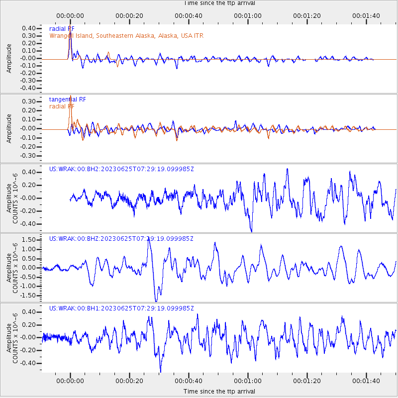
| Radial Match: |
94.25056 % |
| Radial Bump: |
400 |
| Transverse Match: |
75.53548 % |
| Transverse Bump: |
400 |
| SOD ConfigId: |
30536071 |
| Insert Time: |
2023-07-09 07:40:40.893 +0000 |
| GWidth: |
2.5 |
| Max Bumps: |
400 |
| Tol: |
0.001 |
|
Signal To Noise
| Channel | StoN | STA | LTA |
| US:WRAK:00:BHZ:20230625T07:29:19.099985Z | 2.2302442 | 1.3971113E-7 | 6.264388E-8 |
| US:WRAK:00:BH1:20230625T07:29:19.099985Z | 1.5553569 | 5.5936788E-8 | 3.5963957E-8 |
| US:WRAK:00:BH2:20230625T07:29:19.099985Z | 0.86175257 | 6.153361E-8 | 7.1405196E-8 |
| Arrivals |
| Ps | 5.6 SECOND |
| PpPs | 16 SECOND |
| PsPs/PpSs | 22 SECOND |


