You are here: Home > Network List > UW - Pacific Northwest Regional Seismic Network Stations List
> Station LTY Liberty (broad-band) > Earthquake Result Viewer
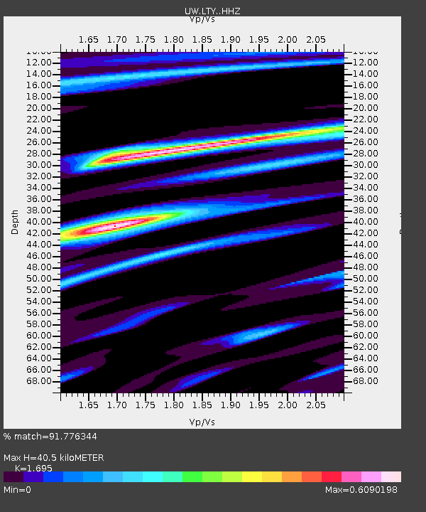
LTY Liberty (broad-band) - Earthquake Result Viewer
| Earthquake location: |
South Of Tonga Islands |
| Earthquake latitude/longitude: |
-24.0/-175.6 |
| Earthquake time(UTC): |
2023/06/25 (176) 07:16:59 GMT |
| Earthquake Depth: |
7.1 km |
| Earthquake Magnitude: |
6.0 mww |
| Earthquake Catalog/Contributor: |
NEIC PDE/us |
|
| Network: |
UW Pacific Northwest Regional Seismic Network |
| Station: |
LTY Liberty (broad-band) |
| Lat/Lon: |
47.26 N/120.66 W |
| Elevation: |
970 m |
|
| Distance: |
86.5 deg |
| Az: |
33.971 deg |
| Baz: |
228.593 deg |
| Ray Param: |
0.044015322 |
| Estimated Moho Depth: |
40.5 km |
| Estimated Crust Vp/Vs: |
1.70 |
| Assumed Crust Vp: |
6.597 km/s |
| Estimated Crust Vs: |
3.892 km/s |
| Estimated Crust Poisson's Ratio: |
0.23 |
|
| Radial Match: |
91.776344 % |
| Radial Bump: |
400 |
| Transverse Match: |
91.99938 % |
| Transverse Bump: |
380 |
| SOD ConfigId: |
30536071 |
| Insert Time: |
2023-07-09 07:42:05.304 +0000 |
| GWidth: |
2.5 |
| Max Bumps: |
400 |
| Tol: |
0.001 |
|

Signal To Noise
| Channel | StoN | STA | LTA |
| UW:LTY: :HHZ:20230625T07:29:11.359995Z | 2.692487 | 1.3186776E-7 | 4.897619E-8 |
| UW:LTY: :HHN:20230625T07:29:11.359995Z | 0.65500444 | 2.4791495E-8 | 3.7849354E-8 |
| UW:LTY: :HHE:20230625T07:29:11.359995Z | 1.3340474 | 3.6029807E-8 | 2.700789E-8 |
| Arrivals |
| Ps | 4.4 SECOND |
| PpPs | 16 SECOND |
| PsPs/PpSs | 21 SECOND |


