You are here: Home > Network List > UW - Pacific Northwest Regional Seismic Network Stations List
> Station OMAK Colville Reservation, Omak, WA, USA > Earthquake Result Viewer
OMAK Colville Reservation, Omak, WA, USA - Earthquake Result Viewer
| Earthquake location: |
South Of Tonga Islands |
| Earthquake latitude/longitude: |
-24.0/-175.6 |
| Earthquake time(UTC): |
2023/06/25 (176) 07:16:59 GMT |
| Earthquake Depth: |
7.1 km |
| Earthquake Magnitude: |
6.0 mww |
| Earthquake Catalog/Contributor: |
NEIC PDE/us |
|
| Network: |
UW Pacific Northwest Regional Seismic Network |
| Station: |
OMAK Colville Reservation, Omak, WA, USA |
| Lat/Lon: |
48.36 N/119.33 W |
| Elevation: |
696 m |
|
| Distance: |
87.9 deg |
| Az: |
33.725 deg |
| Baz: |
229.564 deg |
| Ray Param: |
0.042995673 |
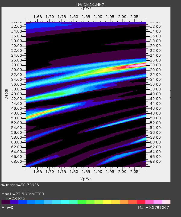
| Estimated Moho Depth: |
27.5 km |
| Estimated Crust Vp/Vs: |
2.10 |
| Assumed Crust Vp: |
6.419 km/s |
| Estimated Crust Vs: |
3.06 km/s |
| Estimated Crust Poisson's Ratio: |
0.35 |
|
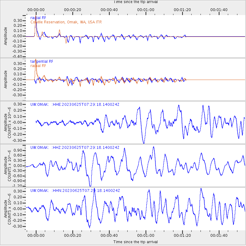
| Radial Match: |
90.73636 % |
| Radial Bump: |
302 |
| Transverse Match: |
79.76545 % |
| Transverse Bump: |
400 |
| SOD ConfigId: |
30536071 |
| Insert Time: |
2023-07-09 07:42:18.847 +0000 |
| GWidth: |
2.5 |
| Max Bumps: |
400 |
| Tol: |
0.001 |
|
Signal To Noise
| Channel | StoN | STA | LTA |
| UW:OMAK: :HHZ:20230625T07:29:18.140024Z | 2.2377207 | 1.0429234E-7 | 4.6606505E-8 |
| UW:OMAK: :HHN:20230625T07:29:18.140024Z | 1.1417449 | 3.6121055E-8 | 3.1636713E-8 |
| UW:OMAK: :HHE:20230625T07:29:18.140024Z | 1.6100453 | 3.2605797E-8 | 2.0251479E-8 |
| Arrivals |
| Ps | 4.8 SECOND |
| PpPs | 13 SECOND |
| PsPs/PpSs | 18 SECOND |


