You are here: Home > Network List > UW - Pacific Northwest Regional Seismic Network Stations List
> Station SHUK Shuksan (Mt. Baker Ski Area), WA > Earthquake Result Viewer
SHUK Shuksan (Mt. Baker Ski Area), WA - Earthquake Result Viewer
| Earthquake location: |
South Of Tonga Islands |
| Earthquake latitude/longitude: |
-24.0/-175.6 |
| Earthquake time(UTC): |
2023/06/25 (176) 07:16:59 GMT |
| Earthquake Depth: |
7.1 km |
| Earthquake Magnitude: |
6.0 mww |
| Earthquake Catalog/Contributor: |
NEIC PDE/us |
|
| Network: |
UW Pacific Northwest Regional Seismic Network |
| Station: |
SHUK Shuksan (Mt. Baker Ski Area), WA |
| Lat/Lon: |
48.85 N/121.68 W |
| Elevation: |
1516 m |
|
| Distance: |
87.1 deg |
| Az: |
32.325 deg |
| Baz: |
227.749 deg |
| Ray Param: |
0.04360729 |
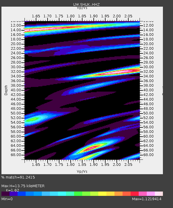
| Estimated Moho Depth: |
13.75 km |
| Estimated Crust Vp/Vs: |
1.62 |
| Assumed Crust Vp: |
6.566 km/s |
| Estimated Crust Vs: |
4.053 km/s |
| Estimated Crust Poisson's Ratio: |
0.19 |
|
| Radial Match: |
91.2415 % |
| Radial Bump: |
332 |
| Transverse Match: |
87.69098 % |
| Transverse Bump: |
400 |
| SOD ConfigId: |
30536071 |
| Insert Time: |
2023-07-09 07:42:35.781 +0000 |
| GWidth: |
2.5 |
| Max Bumps: |
400 |
| Tol: |
0.001 |
|

Signal To Noise
| Channel | StoN | STA | LTA |
| UW:SHUK: :HHZ:20230625T07:29:14.089976Z | 1.8283101 | 9.428522E-8 | 5.1569597E-8 |
| UW:SHUK: :HHN:20230625T07:29:14.089976Z | 1.095015 | 3.2575187E-8 | 2.9748618E-8 |
| UW:SHUK: :HHE:20230625T07:29:14.089976Z | 1.2631595 | 4.4404178E-8 | 3.515326E-8 |
| Arrivals |
| Ps | 1.3 SECOND |
| PpPs | 5.3 SECOND |
| PsPs/PpSs | 6.7 SECOND |


