You are here: Home > Network List > AV - Alaska Volcano Observatory Stations List
> Station N20K Mount Spurr, AK, USA > Earthquake Result Viewer
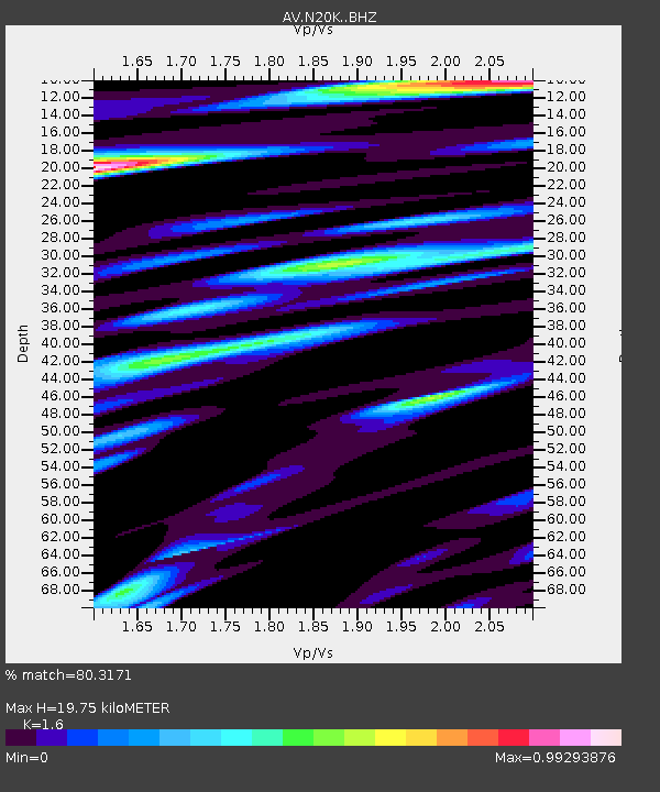
N20K Mount Spurr, AK, USA - Earthquake Result Viewer
| Earthquake location: |
Primor'ye, Russia |
| Earthquake latitude/longitude: |
42.1/134.1 |
| Earthquake time(UTC): |
2023/06/27 (178) 23:38:21 GMT |
| Earthquake Depth: |
443 km |
| Earthquake Magnitude: |
5.8 Mww |
| Earthquake Catalog/Contributor: |
NEIC PDE/us |
|
| Network: |
AV Alaska Volcano Observatory |
| Station: |
N20K Mount Spurr, AK, USA |
| Lat/Lon: |
61.20 N/152.21 W |
| Elevation: |
991 m |
|
| Distance: |
46.7 deg |
| Az: |
39.661 deg |
| Baz: |
281.16 deg |
| Ray Param: |
0.06850165 |
| Estimated Moho Depth: |
19.75 km |
| Estimated Crust Vp/Vs: |
1.60 |
| Assumed Crust Vp: |
6.566 km/s |
| Estimated Crust Vs: |
4.104 km/s |
| Estimated Crust Poisson's Ratio: |
0.18 |
|
| Radial Match: |
80.3171 % |
| Radial Bump: |
400 |
| Transverse Match: |
82.1374 % |
| Transverse Bump: |
400 |
| SOD ConfigId: |
30536071 |
| Insert Time: |
2023-07-11 23:49:08.148 +0000 |
| GWidth: |
2.5 |
| Max Bumps: |
400 |
| Tol: |
0.001 |
|

Signal To Noise
| Channel | StoN | STA | LTA |
| AV:N20K: :BHZ:20230627T23:45:38.550008Z | 20.939974 | 1.5631799E-6 | 7.4650515E-8 |
| AV:N20K: :BHN:20230627T23:45:38.550008Z | 6.3411646 | 4.831749E-7 | 7.619655E-8 |
| AV:N20K: :BHE:20230627T23:45:38.550008Z | 8.476435 | 6.272981E-7 | 7.400495E-8 |
| Arrivals |
| Ps | 1.9 SECOND |
| PpPs | 7.3 SECOND |
| PsPs/PpSs | 9.2 SECOND |


