You are here: Home > Network List > TA - USArray Transportable Network (new EarthScope stations) Stations List
> Station J21A Lysite, WY, USA > Earthquake Result Viewer
J21A Lysite, WY, USA - Earthquake Result Viewer
| Earthquake location: |
Northern Mid-Atlantic Ridge |
| Earthquake latitude/longitude: |
35.3/-35.9 |
| Earthquake time(UTC): |
2010/05/25 (145) 10:09:05 GMT |
| Earthquake Depth: |
10 km |
| Earthquake Magnitude: |
5.5 MB, 5.5 MS, 6.3 MW, 6.3 MW |
| Earthquake Catalog/Contributor: |
WHDF/NEIC |
|
| Network: |
TA USArray Transportable Network (new EarthScope stations) |
| Station: |
J21A Lysite, WY, USA |
| Lat/Lon: |
43.35 N/107.45 W |
| Elevation: |
1913 m |
|
| Distance: |
54.3 deg |
| Az: |
301.625 deg |
| Baz: |
72.613 deg |
| Ray Param: |
0.065503925 |
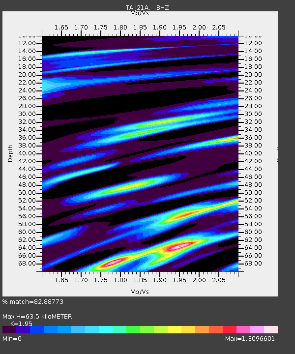
| Estimated Moho Depth: |
63.5 km |
| Estimated Crust Vp/Vs: |
1.95 |
| Assumed Crust Vp: |
6.178 km/s |
| Estimated Crust Vs: |
3.168 km/s |
| Estimated Crust Poisson's Ratio: |
0.32 |
|
| Radial Match: |
82.88773 % |
| Radial Bump: |
400 |
| Transverse Match: |
64.18655 % |
| Transverse Bump: |
400 |
| SOD ConfigId: |
314592 |
| Insert Time: |
2010-09-14 06:37:21.994 +0000 |
| GWidth: |
2.5 |
| Max Bumps: |
400 |
| Tol: |
0.001 |
|
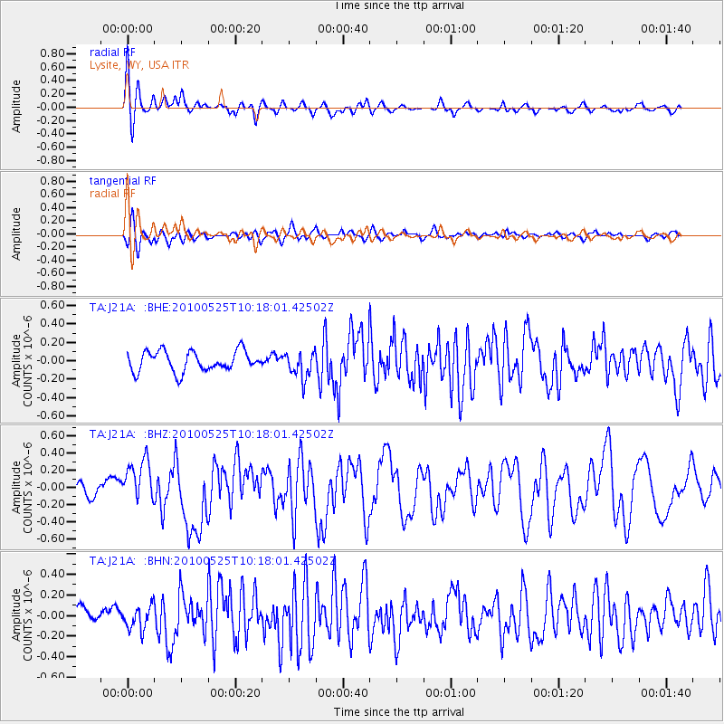
Signal To Noise
| Channel | StoN | STA | LTA |
| TA:J21A: :BHZ:20100525T10:18:01.42502Z | 2.6178555 | 2.5813767E-7 | 9.8606534E-8 |
| TA:J21A: :BHN:20100525T10:18:01.42502Z | 1.0073291 | 1.1501354E-7 | 1.1417673E-7 |
| TA:J21A: :BHE:20100525T10:18:01.42502Z | 1.3111131 | 1.4268417E-7 | 1.0882675E-7 |
| Arrivals |
| Ps | 10 SECOND |
| PpPs | 29 SECOND |
| PsPs/PpSs | 39 SECOND |


