You are here: Home > Network List > TA - USArray Transportable Network (new EarthScope stations) Stations List
> Station X28A Dimmitt, TX, USA > Earthquake Result Viewer
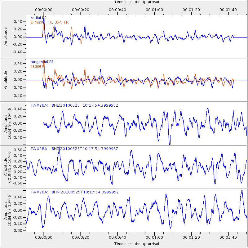
X28A Dimmitt, TX, USA - Earthquake Result Viewer
*The percent match for this event was below the threshold and hence no stack was calculated.
| Earthquake location: |
Northern Mid-Atlantic Ridge |
| Earthquake latitude/longitude: |
35.3/-35.9 |
| Earthquake time(UTC): |
2010/05/25 (145) 10:09:05 GMT |
| Earthquake Depth: |
10 km |
| Earthquake Magnitude: |
5.5 MB, 5.5 MS, 6.3 MW, 6.3 MW |
| Earthquake Catalog/Contributor: |
WHDF/NEIC |
|
| Network: |
TA USArray Transportable Network (new EarthScope stations) |
| Station: |
X28A Dimmitt, TX, USA |
| Lat/Lon: |
34.52 N/102.20 W |
| Elevation: |
1160 m |
|
| Distance: |
53.4 deg |
| Az: |
289.649 deg |
| Baz: |
68.831 deg |
| Ray Param: |
$rayparam |
*The percent match for this event was below the threshold and hence was not used in the summary stack. |
|
| Radial Match: |
65.64885 % |
| Radial Bump: |
398 |
| Transverse Match: |
54.425568 % |
| Transverse Bump: |
328 |
| SOD ConfigId: |
314592 |
| Insert Time: |
2010-09-14 06:39:23.575 +0000 |
| GWidth: |
2.5 |
| Max Bumps: |
400 |
| Tol: |
0.001 |
|
Signal To Noise
| Channel | StoN | STA | LTA |
| TA:X28A: :BHZ:20100525T10:17:54.399995Z | 0.5544844 | 9.282609E-8 | 1.6740974E-7 |
| TA:X28A: :BHN:20100525T10:17:54.399995Z | 1.8414447 | 3.071779E-7 | 1.6681354E-7 |
| TA:X28A: :BHE:20100525T10:17:54.399995Z | 1.5681556 | 2.0711303E-7 | 1.3207428E-7 |
| Arrivals |
| Ps | |
| PpPs | |
| PsPs/PpSs | |


