You are here: Home > Network List > TA - USArray Transportable Network (new EarthScope stations) Stations List
> Station P28A Satin Francis, KS, USA > Earthquake Result Viewer
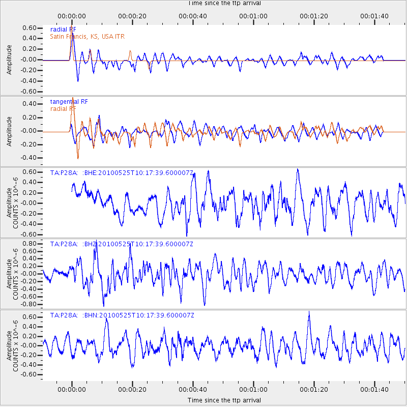
P28A Satin Francis, KS, USA - Earthquake Result Viewer
*The percent match for this event was below the threshold and hence no stack was calculated.
| Earthquake location: |
Northern Mid-Atlantic Ridge |
| Earthquake latitude/longitude: |
35.3/-35.9 |
| Earthquake time(UTC): |
2010/05/25 (145) 10:09:05 GMT |
| Earthquake Depth: |
10 km |
| Earthquake Magnitude: |
5.5 MB, 5.5 MS, 6.3 MW, 6.3 MW |
| Earthquake Catalog/Contributor: |
WHDF/NEIC |
|
| Network: |
TA USArray Transportable Network (new EarthScope stations) |
| Station: |
P28A Satin Francis, KS, USA |
| Lat/Lon: |
39.57 N/101.75 W |
| Elevation: |
1105 m |
|
| Distance: |
51.4 deg |
| Az: |
295.515 deg |
| Baz: |
72.68 deg |
| Ray Param: |
$rayparam |
*The percent match for this event was below the threshold and hence was not used in the summary stack. |
|
| Radial Match: |
61.370922 % |
| Radial Bump: |
400 |
| Transverse Match: |
53.631744 % |
| Transverse Bump: |
392 |
| SOD ConfigId: |
314592 |
| Insert Time: |
2010-09-14 06:41:43.591 +0000 |
| GWidth: |
2.5 |
| Max Bumps: |
400 |
| Tol: |
0.001 |
|
Signal To Noise
| Channel | StoN | STA | LTA |
| TA:P28A: :BHZ:20100525T10:17:39.600007Z | 3.0115948 | 2.5527382E-7 | 8.476367E-8 |
| TA:P28A: :BHN:20100525T10:17:39.600007Z | 0.6845935 | 1.3452222E-7 | 1.9649943E-7 |
| TA:P28A: :BHE:20100525T10:17:39.600007Z | 1.3108466 | 2.5293767E-7 | 1.929575E-7 |
| Arrivals |
| Ps | |
| PpPs | |
| PsPs/PpSs | |


