You are here: Home > Network List > TA - USArray Transportable Network (new EarthScope stations) Stations List
> Station P30A Selden, KS, USA > Earthquake Result Viewer
P30A Selden, KS, USA - Earthquake Result Viewer
| Earthquake location: |
Northern Mid-Atlantic Ridge |
| Earthquake latitude/longitude: |
35.3/-35.9 |
| Earthquake time(UTC): |
2010/05/25 (145) 10:09:05 GMT |
| Earthquake Depth: |
10 km |
| Earthquake Magnitude: |
5.5 MB, 5.5 MS, 6.3 MW, 6.3 MW |
| Earthquake Catalog/Contributor: |
WHDF/NEIC |
|
| Network: |
TA USArray Transportable Network (new EarthScope stations) |
| Station: |
P30A Selden, KS, USA |
| Lat/Lon: |
39.54 N/100.25 W |
| Elevation: |
788 m |
|
| Distance: |
50.3 deg |
| Az: |
295.04 deg |
| Baz: |
73.336 deg |
| Ray Param: |
0.068164036 |
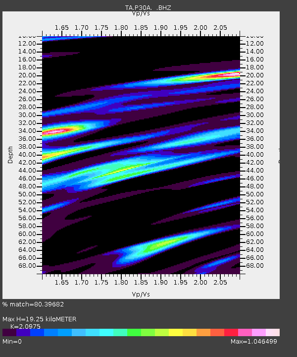
| Estimated Moho Depth: |
19.25 km |
| Estimated Crust Vp/Vs: |
2.10 |
| Assumed Crust Vp: |
6.483 km/s |
| Estimated Crust Vs: |
3.091 km/s |
| Estimated Crust Poisson's Ratio: |
0.35 |
|
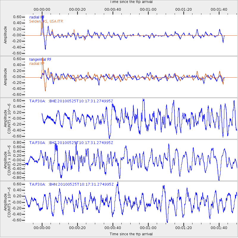
| Radial Match: |
80.39682 % |
| Radial Bump: |
391 |
| Transverse Match: |
56.440224 % |
| Transverse Bump: |
400 |
| SOD ConfigId: |
314592 |
| Insert Time: |
2010-09-14 06:42:07.736 +0000 |
| GWidth: |
2.5 |
| Max Bumps: |
400 |
| Tol: |
0.001 |
|
Signal To Noise
| Channel | StoN | STA | LTA |
| TA:P30A: :BHZ:20100525T10:17:31.274995Z | 2.3482263 | 2.4054077E-7 | 1.0243508E-7 |
| TA:P30A: :BHN:20100525T10:17:31.274995Z | 1.5022396 | 1.9495299E-7 | 1.297749E-7 |
| TA:P30A: :BHE:20100525T10:17:31.274995Z | 1.0644783 | 1.5210814E-7 | 1.4289455E-7 |
| Arrivals |
| Ps | 3.4 SECOND |
| PpPs | 8.8 SECOND |
| PsPs/PpSs | 12 SECOND |


