You are here: Home > Network List > TA - USArray Transportable Network (new EarthScope stations) Stations List
> Station H28A Mission Ridge, SD, USA > Earthquake Result Viewer
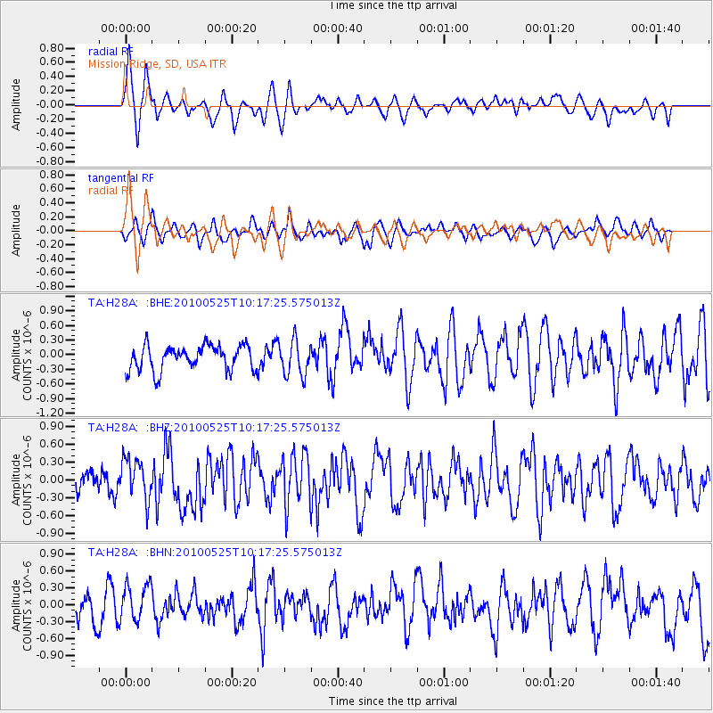
H28A Mission Ridge, SD, USA - Earthquake Result Viewer
*The percent match for this event was below the threshold and hence no stack was calculated.
| Earthquake location: |
Northern Mid-Atlantic Ridge |
| Earthquake latitude/longitude: |
35.3/-35.9 |
| Earthquake time(UTC): |
2010/05/25 (145) 10:09:05 GMT |
| Earthquake Depth: |
10 km |
| Earthquake Magnitude: |
5.5 MB, 5.5 MS, 6.3 MW, 6.3 MW |
| Earthquake Catalog/Contributor: |
WHDF/NEIC |
|
| Network: |
TA USArray Transportable Network (new EarthScope stations) |
| Station: |
H28A Mission Ridge, SD, USA |
| Lat/Lon: |
44.68 N/101.02 W |
| Elevation: |
642 m |
|
| Distance: |
49.5 deg |
| Az: |
301.715 deg |
| Baz: |
77.121 deg |
| Ray Param: |
$rayparam |
*The percent match for this event was below the threshold and hence was not used in the summary stack. |
|
| Radial Match: |
71.39135 % |
| Radial Bump: |
394 |
| Transverse Match: |
51.02014 % |
| Transverse Bump: |
383 |
| SOD ConfigId: |
314592 |
| Insert Time: |
2010-09-14 06:43:00.502 +0000 |
| GWidth: |
2.5 |
| Max Bumps: |
400 |
| Tol: |
0.001 |
|
Signal To Noise
| Channel | StoN | STA | LTA |
| TA:H28A: :BHZ:20100525T10:17:25.575013Z | 2.582723 | 3.4616855E-7 | 1.3403239E-7 |
| TA:H28A: :BHN:20100525T10:17:25.575013Z | 1.2673341 | 3.3396734E-7 | 2.6351955E-7 |
| TA:H28A: :BHE:20100525T10:17:25.575013Z | 1.4192722 | 3.5991062E-7 | 2.5358815E-7 |
| Arrivals |
| Ps | |
| PpPs | |
| PsPs/PpSs | |


