You are here: Home > Network List > TA - USArray Transportable Network (new EarthScope stations) Stations List
> Station G27A Dupree, SD, USA > Earthquake Result Viewer
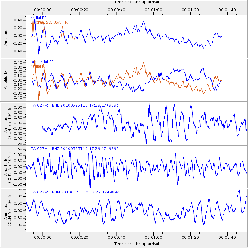
G27A Dupree, SD, USA - Earthquake Result Viewer
*The percent match for this event was below the threshold and hence no stack was calculated.
| Earthquake location: |
Northern Mid-Atlantic Ridge |
| Earthquake latitude/longitude: |
35.3/-35.9 |
| Earthquake time(UTC): |
2010/05/25 (145) 10:09:05 GMT |
| Earthquake Depth: |
10 km |
| Earthquake Magnitude: |
5.5 MB, 5.5 MS, 6.3 MW, 6.3 MW |
| Earthquake Catalog/Contributor: |
WHDF/NEIC |
|
| Network: |
TA USArray Transportable Network (new EarthScope stations) |
| Station: |
G27A Dupree, SD, USA |
| Lat/Lon: |
45.38 N/102.93 W |
| Elevation: |
761 m |
|
| Distance: |
50.7 deg |
| Az: |
303.01 deg |
| Baz: |
76.604 deg |
| Ray Param: |
$rayparam |
*The percent match for this event was below the threshold and hence was not used in the summary stack. |
|
| Radial Match: |
46.69157 % |
| Radial Bump: |
400 |
| Transverse Match: |
29.688099 % |
| Transverse Bump: |
400 |
| SOD ConfigId: |
314592 |
| Insert Time: |
2010-09-14 06:43:23.371 +0000 |
| GWidth: |
2.5 |
| Max Bumps: |
400 |
| Tol: |
0.001 |
|
Signal To Noise
| Channel | StoN | STA | LTA |
| TA:G27A: :BHZ:20100525T10:17:29.174989Z | 3.5857115 | 5.9697965E-7 | 1.6648848E-7 |
| TA:G27A: :BHN:20100525T10:17:29.174989Z | 0.47778907 | 2.8772354E-7 | 6.021978E-7 |
| TA:G27A: :BHE:20100525T10:17:29.174989Z | 1.4237286 | 3.8185505E-7 | 2.6820774E-7 |
| Arrivals |
| Ps | |
| PpPs | |
| PsPs/PpSs | |


