You are here: Home > Network List > TA - USArray Transportable Network (new EarthScope stations) Stations List
> Station E27A Carson, ND, USA > Earthquake Result Viewer
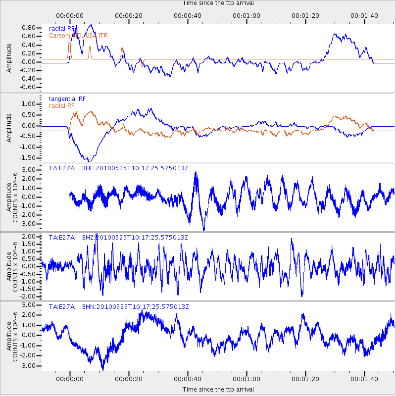
E27A Carson, ND, USA - Earthquake Result Viewer
*The percent match for this event was below the threshold and hence no stack was calculated.
| Earthquake location: |
Northern Mid-Atlantic Ridge |
| Earthquake latitude/longitude: |
35.3/-35.9 |
| Earthquake time(UTC): |
2010/05/25 (145) 10:09:05 GMT |
| Earthquake Depth: |
10 km |
| Earthquake Magnitude: |
5.5 MB, 5.5 MS, 6.3 MW, 6.3 MW |
| Earthquake Catalog/Contributor: |
WHDF/NEIC |
|
| Network: |
TA USArray Transportable Network (new EarthScope stations) |
| Station: |
E27A Carson, ND, USA |
| Lat/Lon: |
46.43 N/101.56 W |
| Elevation: |
738 m |
|
| Distance: |
49.5 deg |
| Az: |
304.075 deg |
| Baz: |
78.266 deg |
| Ray Param: |
$rayparam |
*The percent match for this event was below the threshold and hence was not used in the summary stack. |
|
| Radial Match: |
47.908813 % |
| Radial Bump: |
400 |
| Transverse Match: |
63.708477 % |
| Transverse Bump: |
400 |
| SOD ConfigId: |
314592 |
| Insert Time: |
2010-09-14 06:43:48.293 +0000 |
| GWidth: |
2.5 |
| Max Bumps: |
400 |
| Tol: |
0.001 |
|
Signal To Noise
| Channel | StoN | STA | LTA |
| TA:E27A: :BHZ:20100525T10:17:25.575013Z | 1.3569385 | 5.3606016E-7 | 3.950512E-7 |
| TA:E27A: :BHN:20100525T10:17:25.575013Z | 2.1991854 | 1.4734226E-6 | 6.699856E-7 |
| TA:E27A: :BHE:20100525T10:17:25.575013Z | 0.82155544 | 4.971355E-7 | 6.05115E-7 |
| Arrivals |
| Ps | |
| PpPs | |
| PsPs/PpSs | |


