You are here: Home > Network List > TA - USArray Transportable Network (new EarthScope stations) Stations List
> Station F30A Leola, SD, USA > Earthquake Result Viewer
F30A Leola, SD, USA - Earthquake Result Viewer
| Earthquake location: |
Northern Mid-Atlantic Ridge |
| Earthquake latitude/longitude: |
35.3/-35.9 |
| Earthquake time(UTC): |
2010/05/25 (145) 10:09:05 GMT |
| Earthquake Depth: |
10 km |
| Earthquake Magnitude: |
5.5 MB, 5.5 MS, 6.3 MW, 6.3 MW |
| Earthquake Catalog/Contributor: |
WHDF/NEIC |
|
| Network: |
TA USArray Transportable Network (new EarthScope stations) |
| Station: |
F30A Leola, SD, USA |
| Lat/Lon: |
45.84 N/99.03 W |
| Elevation: |
601 m |
|
| Distance: |
47.9 deg |
| Az: |
302.843 deg |
| Baz: |
79.278 deg |
| Ray Param: |
0.06969183 |
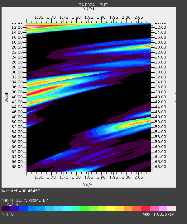
| Estimated Moho Depth: |
11.75 km |
| Estimated Crust Vp/Vs: |
1.60 |
| Assumed Crust Vp: |
6.53 km/s |
| Estimated Crust Vs: |
4.082 km/s |
| Estimated Crust Poisson's Ratio: |
0.18 |
|
| Radial Match: |
80.46452 % |
| Radial Bump: |
323 |
| Transverse Match: |
46.963085 % |
| Transverse Bump: |
323 |
| SOD ConfigId: |
314592 |
| Insert Time: |
2010-09-14 06:44:51.489 +0000 |
| GWidth: |
2.5 |
| Max Bumps: |
400 |
| Tol: |
0.001 |
|
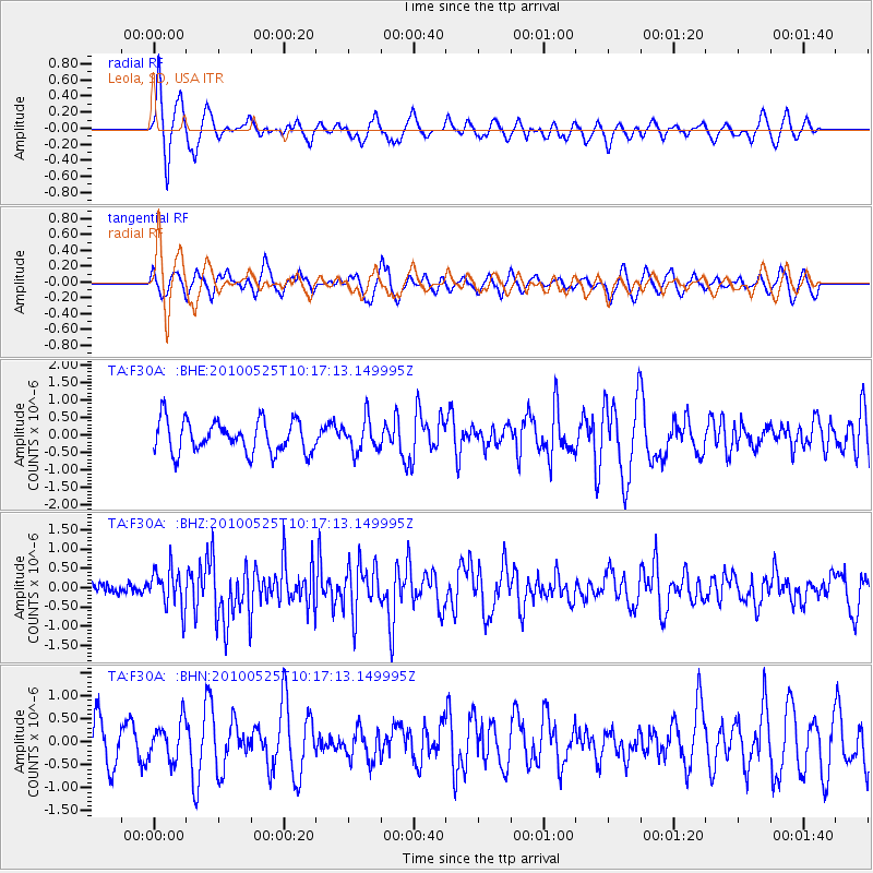
Signal To Noise
| Channel | StoN | STA | LTA |
| TA:F30A: :BHZ:20100525T10:17:13.149995Z | 3.336764 | 5.1203824E-7 | 1.5345354E-7 |
| TA:F30A: :BHN:20100525T10:17:13.149995Z | 0.6424341 | 4.0895156E-7 | 6.3656574E-7 |
| TA:F30A: :BHE:20100525T10:17:13.149995Z | 0.98145103 | 4.5080117E-7 | 4.593211E-7 |
| Arrivals |
| Ps | 1.2 SECOND |
| PpPs | 4.4 SECOND |
| PsPs/PpSs | 5.5 SECOND |


