You are here: Home > Network List > TA - USArray Transportable Network (new EarthScope stations) Stations List
> Station M31A Lambtecht Ranch, Loup City, NE, USA > Earthquake Result Viewer
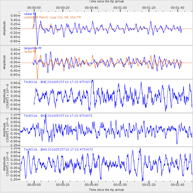
M31A Lambtecht Ranch, Loup City, NE, USA - Earthquake Result Viewer
*The percent match for this event was below the threshold and hence no stack was calculated.
| Earthquake location: |
Northern Mid-Atlantic Ridge |
| Earthquake latitude/longitude: |
35.3/-35.9 |
| Earthquake time(UTC): |
2010/05/25 (145) 10:09:05 GMT |
| Earthquake Depth: |
10 km |
| Earthquake Magnitude: |
5.5 MB, 5.5 MS, 6.3 MW, 6.3 MW |
| Earthquake Catalog/Contributor: |
WHDF/NEIC |
|
| Network: |
TA USArray Transportable Network (new EarthScope stations) |
| Station: |
M31A Lambtecht Ranch, Loup City, NE, USA |
| Lat/Lon: |
41.34 N/98.98 W |
| Elevation: |
699 m |
|
| Distance: |
48.9 deg |
| Az: |
296.972 deg |
| Baz: |
75.41 deg |
| Ray Param: |
$rayparam |
*The percent match for this event was below the threshold and hence was not used in the summary stack. |
|
| Radial Match: |
58.135624 % |
| Radial Bump: |
392 |
| Transverse Match: |
50.456284 % |
| Transverse Bump: |
367 |
| SOD ConfigId: |
314592 |
| Insert Time: |
2010-09-14 06:45:05.540 +0000 |
| GWidth: |
2.5 |
| Max Bumps: |
400 |
| Tol: |
0.001 |
|
Signal To Noise
| Channel | StoN | STA | LTA |
| TA:M31A: :BHZ:20100525T10:17:20.475007Z | 2.3194404 | 2.996237E-7 | 1.2917931E-7 |
| TA:M31A: :BHN:20100525T10:17:20.475007Z | 0.8846962 | 3.5927349E-7 | 4.0609817E-7 |
| TA:M31A: :BHE:20100525T10:17:20.475007Z | 0.9118867 | 2.6436584E-7 | 2.8991082E-7 |
| Arrivals |
| Ps | |
| PpPs | |
| PsPs/PpSs | |


