You are here: Home > Network List > ND - New CaleDonia Broadband Seismic Network Stations List
> Station KOUNC Koumac, New Caledonia > Earthquake Result Viewer
KOUNC Koumac, New Caledonia - Earthquake Result Viewer

| Earthquake location: |
Near East Coast Of Kamchatka |
| Earthquake latitude/longitude: |
55.6/162.0 |
| Earthquake time(UTC): |
2018/11/14 (318) 21:21:50 GMT |
| Earthquake Depth: |
50 km |
| Earthquake Magnitude: |
6.1 Mww |
| Earthquake Catalog/Contributor: |
NEIC PDE/us |
|
| Network: |
ND New CaleDonia Broadband Seismic Network |
| Station: |
KOUNC Koumac, New Caledonia |
| Lat/Lon: |
20.55 S/164.29 E |
| Elevation: |
88 m |
|
| Distance: |
75.9 deg |
| Az: |
177.792 deg |
| Baz: |
358.664 deg |
| Ray Param: |
0.05126129 |
| Estimated Moho Depth: |
22.25 km |
| Estimated Crust Vp/Vs: |
1.90 |
| Assumed Crust Vp: |
5.14 km/s |
| Estimated Crust Vs: |
2.698 km/s |
| Estimated Crust Poisson's Ratio: |
0.31 |
|
| Radial Match: |
82.46045 % |
| Radial Bump: |
400 |
| Transverse Match: |
83.85192 % |
| Transverse Bump: |
400 |
| SOD ConfigId: |
3165032 |
| Insert Time: |
2018-11-28 21:35:18.645 +0000 |
| GWidth: |
2.5 |
| Max Bumps: |
400 |
| Tol: |
0.001 |
|
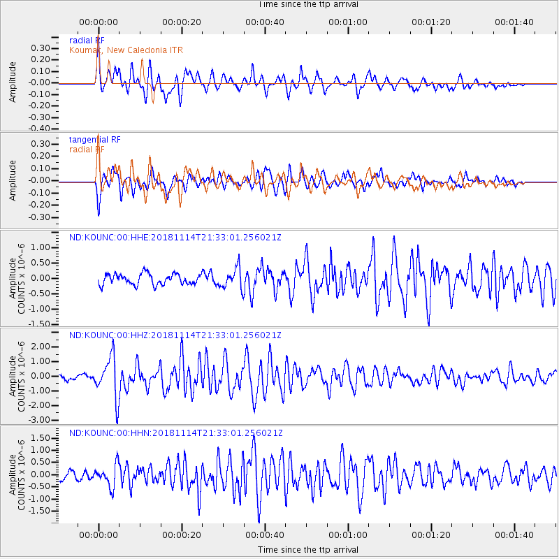
Signal To Noise
| Channel | StoN | STA | LTA |
| ND:KOUNC:00:HHZ:20181114T21:33:01.256021Z | 9.03567 | 1.4464061E-6 | 1.6007735E-7 |
| ND:KOUNC:00:HHN:20181114T21:33:01.256021Z | 3.3193972 | 4.6485246E-7 | 1.4004124E-7 |
| ND:KOUNC:00:HHE:20181114T21:33:01.256021Z | 1.9704287 | 3.4258596E-7 | 1.7386367E-7 |
| Arrivals |
| Ps | 4.0 SECOND |
| PpPs | 12 SECOND |
| PsPs/PpSs | 16 SECOND |


