You are here: Home > Network List > NM - Cooperative New Madrid Seismic Network Stations List
> Station HENM Henderson Mound,MO > Earthquake Result Viewer
HENM Henderson Mound,MO - Earthquake Result Viewer
| Earthquake location: |
Near East Coast Of Kamchatka |
| Earthquake latitude/longitude: |
55.6/162.0 |
| Earthquake time(UTC): |
2018/11/14 (318) 21:21:50 GMT |
| Earthquake Depth: |
50 km |
| Earthquake Magnitude: |
6.1 Mww |
| Earthquake Catalog/Contributor: |
NEIC PDE/us |
|
| Network: |
NM Cooperative New Madrid Seismic Network |
| Station: |
HENM Henderson Mound,MO |
| Lat/Lon: |
36.72 N/89.47 W |
| Elevation: |
88 m |
|
| Distance: |
69.8 deg |
| Az: |
54.28 deg |
| Baz: |
325.042 deg |
| Ray Param: |
0.055313725 |
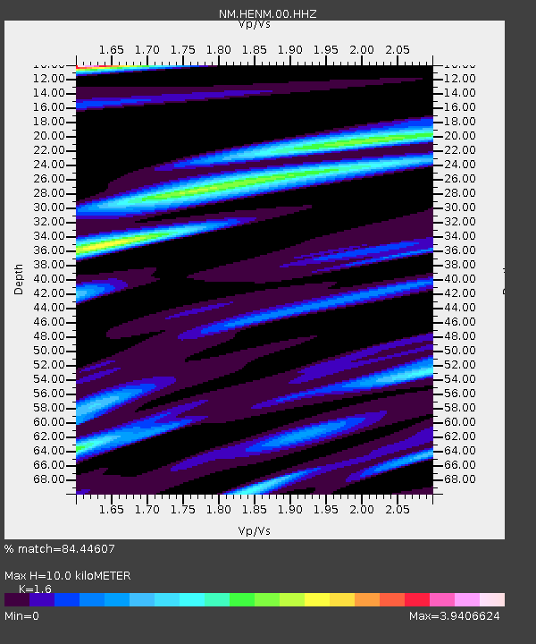
| Estimated Moho Depth: |
10.0 km |
| Estimated Crust Vp/Vs: |
1.60 |
| Assumed Crust Vp: |
6.444 km/s |
| Estimated Crust Vs: |
4.027 km/s |
| Estimated Crust Poisson's Ratio: |
0.18 |
|
| Radial Match: |
84.44607 % |
| Radial Bump: |
400 |
| Transverse Match: |
71.09136 % |
| Transverse Bump: |
400 |
| SOD ConfigId: |
3165032 |
| Insert Time: |
2018-11-28 21:35:43.238 +0000 |
| GWidth: |
2.5 |
| Max Bumps: |
400 |
| Tol: |
0.001 |
|

Signal To Noise
| Channel | StoN | STA | LTA |
| NM:HENM:00:HHZ:20181114T21:32:25.139993Z | 7.4759393 | 3.0871336E-6 | 4.1294257E-7 |
| NM:HENM:00:HHN:20181114T21:32:25.139993Z | 2.3671331 | 1.9651666E-6 | 8.301884E-7 |
| NM:HENM:00:HHE:20181114T21:32:25.139993Z | 2.7317755 | 1.8309718E-6 | 6.702497E-7 |
| Arrivals |
| Ps | 1.0 SECOND |
| PpPs | 3.9 SECOND |
| PsPs/PpSs | 4.8 SECOND |


