You are here: Home > Network List > TA - USArray Transportable Network (new EarthScope stations) Stations List
> Station Z37A Pogue Cattle Company, Sulphur Springs, TX, USA > Earthquake Result Viewer
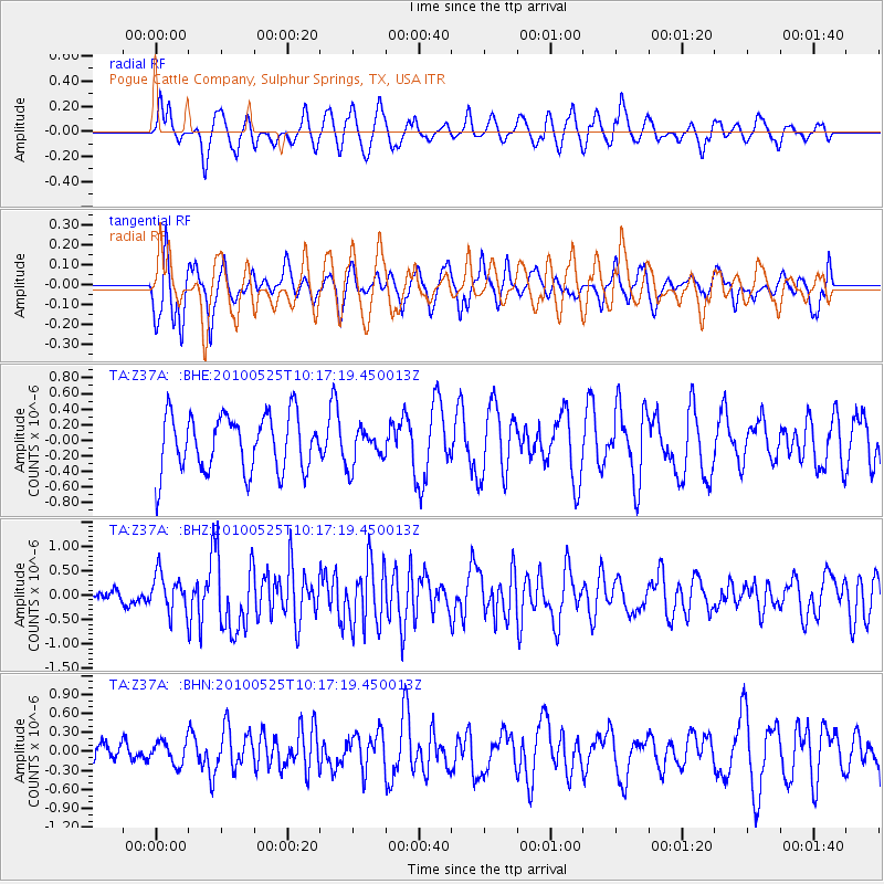
Z37A Pogue Cattle Company, Sulphur Springs, TX, USA - Earthquake Result Viewer
*The percent match for this event was below the threshold and hence no stack was calculated.
| Earthquake location: |
Northern Mid-Atlantic Ridge |
| Earthquake latitude/longitude: |
35.3/-35.9 |
| Earthquake time(UTC): |
2010/05/25 (145) 10:09:05 GMT |
| Earthquake Depth: |
10 km |
| Earthquake Magnitude: |
5.5 MB, 5.5 MS, 6.3 MW, 6.3 MW |
| Earthquake Catalog/Contributor: |
WHDF/NEIC |
|
| Network: |
TA USArray Transportable Network (new EarthScope stations) |
| Station: |
Z37A Pogue Cattle Company, Sulphur Springs, TX, USA |
| Lat/Lon: |
33.20 N/95.62 W |
| Elevation: |
146 m |
|
| Distance: |
48.7 deg |
| Az: |
285.59 deg |
| Baz: |
69.926 deg |
| Ray Param: |
$rayparam |
*The percent match for this event was below the threshold and hence was not used in the summary stack. |
|
| Radial Match: |
65.90067 % |
| Radial Bump: |
400 |
| Transverse Match: |
55.97448 % |
| Transverse Bump: |
400 |
| SOD ConfigId: |
314592 |
| Insert Time: |
2010-09-14 06:48:07.997 +0000 |
| GWidth: |
2.5 |
| Max Bumps: |
400 |
| Tol: |
0.001 |
|
Signal To Noise
| Channel | StoN | STA | LTA |
| TA:Z37A: :BHZ:20100525T10:17:19.450013Z | 3.2955267 | 3.9493943E-7 | 1.1984106E-7 |
| TA:Z37A: :BHN:20100525T10:17:19.450013Z | 0.8766965 | 1.8259045E-7 | 2.0827099E-7 |
| TA:Z37A: :BHE:20100525T10:17:19.450013Z | 0.64235616 | 2.3061561E-7 | 3.590152E-7 |
| Arrivals |
| Ps | |
| PpPs | |
| PsPs/PpSs | |


