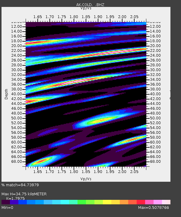
COLD Coldfoot Broadband - Earthquake Result Viewer
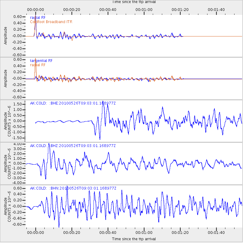
Earthquake location: Southeast Of Ryukyu Islands
Earthquake latitude/longitude: 25.8/129.9
Earthquake time(UTC): 2010/05/26 (146) 08:53:08 GMT
Earthquake Depth: 10 km
Earthquake Magnitude: 6.2 MB, 6.2 MS, 6.5 MW, 6.5 MW
Earthquake Catalog/Contributor: WHDF/NEIC
Network: AK Alaska Regional Network
Station: COLD Coldfoot Broadband
Lat/Lon: 67.23 N/150.20 W
Elevation: 377 m
Distance: 62.6 deg
Az: 25.57 deg
Baz: 271.423 deg
Ray Param: 0.06011784
Estimated Moho Depth: 34.75 km
Estimated Crust Vp/Vs: 1.80
Assumed Crust Vp: 6.577 km/s
Estimated Crust Vs: 3.659 km/s
Estimated Crust Poisson's Ratio: 0.28
Radial Match: 94.73979 %
Radial Bump: 400
Transverse Match: 81.052315 %
Transverse Bump: 400
SOD ConfigId: 314592
Insert Time: 2010-09-14 06:51:38.432 +0000
GWidth: 2.5
Max Bumps: 400
Tol: 0.001

Signal To Noise

ChannelStoNSTALTA
AK:COLD: :BHZ:20100526T09:03:01.168977Z13.9389848.620303E-76.1843124E-8
AK:COLD: :BHN:20100526T09:03:01.168977Z1.70916497.1401416E-84.1775618E-8
AK:COLD: :BHE:20100526T09:03:01.168977Z8.471014.393803E-75.18687E-8
Arrivals
Ps4.4 SECOND
PpPs14 SECOND
PsPs/PpSs19 SECOND