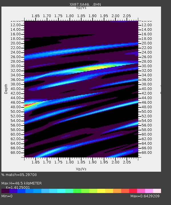
SA46 XA.SA46 - Earthquake Result Viewer
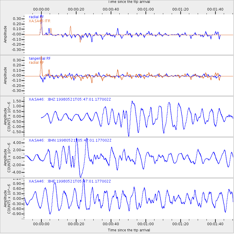
Earthquake location: Minahassa Peninsula, Sulawesi
Earthquake latitude/longitude: 0.2/119.6
Earthquake time(UTC): 1998/05/21 (141) 05:34:25 GMT
Earthquake Depth: 33 km
Earthquake Magnitude: 6.2 MB, 6.3 MS, 6.6 UNKNOWN, 6.6 MW
Earthquake Catalog/Contributor: WHDF/NEIC
Network: XA Anatomy of an Archean Craton, South Africa
Station: SA46 XA.SA46
Lat/Lon: 24.84 S/27.11 E
Elevation: 1037 m
Distance: 92.3 deg
Az: 245.295 deg
Baz: 90.847 deg
Ray Param: 0.04146548
Estimated Moho Depth: 46.5 km
Estimated Crust Vp/Vs: 1.61
Assumed Crust Vp: 6.459 km/s
Estimated Crust Vs: 4.006 km/s
Estimated Crust Poisson's Ratio: 0.19
Radial Match: 85.29708 %
Radial Bump: 340
Transverse Match: 61.065742 %
Transverse Bump: 400
SOD ConfigId: 4480
Insert Time: 2010-02-26 18:15:58.570 +0000
GWidth: 2.5
Max Bumps: 400
Tol: 0.001

Signal To Noise

ChannelStoNSTALTA
XA:SA46: :BHN:19980521T05:47:01.177002Z2.33099321.1081789E-64.7541062E-7
XA:SA46: :BHE:19980521T05:47:01.177002Z2.22032864.74872E-72.1387466E-7
XA:SA46: :BHZ:19980521T05:47:01.177002Z1.8011014.727378E-72.624716E-7
Arrivals
Ps4.5 SECOND
PpPs18 SECOND
PsPs/PpSs23 SECOND