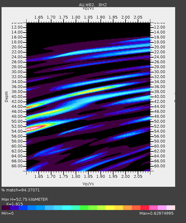
WB2 Warramunga Array, NT - Earthquake Result Viewer

Earthquake location: Southeast Of Ryukyu Islands
Earthquake latitude/longitude: 25.8/129.9
Earthquake time(UTC): 2010/05/26 (146) 08:53:08 GMT
Earthquake Depth: 10 km
Earthquake Magnitude: 6.2 MB, 6.2 MS, 6.5 MW, 6.5 MW
Earthquake Catalog/Contributor: WHDF/NEIC
Network: AU Australian Seismological Centre
Station: WB2 Warramunga Array, NT
Lat/Lon: 19.94 S/134.35 E
Elevation: 425 m
Distance: 45.6 deg
Az: 174.197 deg
Baz: 354.439 deg
Ray Param: 0.07114237
Estimated Moho Depth: 52.75 km
Estimated Crust Vp/Vs: 1.62
Assumed Crust Vp: 6.642 km/s
Estimated Crust Vs: 4.113 km/s
Estimated Crust Poisson's Ratio: 0.19
Radial Match: 94.37071 %
Radial Bump: 344
Transverse Match: 80.91058 %
Transverse Bump: 400
SOD ConfigId: 314592
Insert Time: 2010-09-14 06:53:09.560 +0000
GWidth: 2.5
Max Bumps: 400
Tol: 0.001

Signal To Noise

ChannelStoNSTALTA
AU:WB2: :BHZ:20100526T09:00:57.700013Z6.94699571.222099E-61.7591762E-7
AU:WB2: :BHN:20100526T09:00:57.700013Z5.73898847.0305697E-71.2250538E-7
AU:WB2: :BHE:20100526T09:00:57.700013Z1.54101092.5508507E-71.6553099E-7
Arrivals
Ps5.3 SECOND
PpPs19 SECOND
PsPs/PpSs25 SECOND