You are here: Home > Network List > TX - Texas Seismological Network Stations List
> Station WTFS Witchita Falls > Earthquake Result Viewer
WTFS Witchita Falls - Earthquake Result Viewer
*The percent match for this event was below the threshold and hence no stack was calculated.
| Earthquake location: |
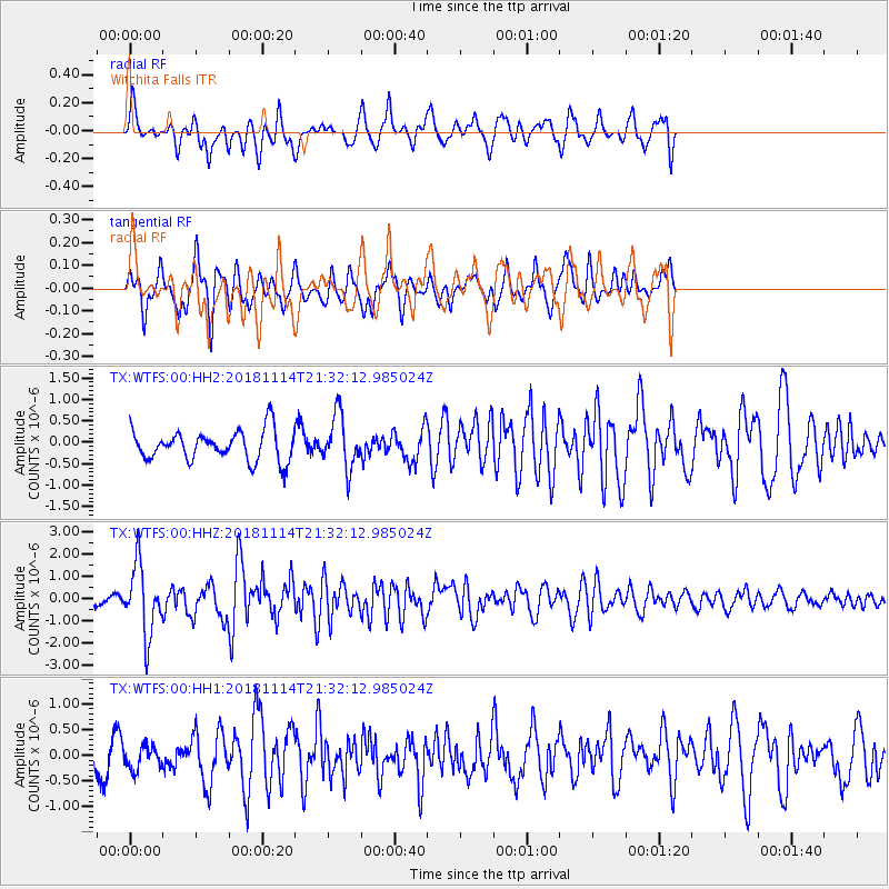
Near East Coast Of Kamchatka |
| Earthquake latitude/longitude: |
55.6/162.0 |
| Earthquake time(UTC): |
2018/11/14 (318) 21:21:50 GMT |
| Earthquake Depth: |
50 km |
| Earthquake Magnitude: |
6.1 Mww |
| Earthquake Catalog/Contributor: |
NEIC PDE/us |
|
| Network: |
TX Texas Seismological Network |
| Station: |
WTFS Witchita Falls |
| Lat/Lon: |
33.77 N/98.46 W |
| Elevation: |
277 m |
|
| Distance: |
67.8 deg |
| Az: |
62.515 deg |
| Baz: |
322.849 deg |
| Ray Param: |
$rayparam |
*The percent match for this event was below the threshold and hence was not used in the summary stack. |
|
| Radial Match: |
79.507515 % |
| Radial Bump: |
400 |
| Transverse Match: |
72.76438 % |
| Transverse Bump: |
359 |
| SOD ConfigId: |
3165032 |
| Insert Time: |
2018-11-28 21:37:52.537 +0000 |
| GWidth: |
2.5 |
| Max Bumps: |
400 |
| Tol: |
0.001 |
|
Signal To Noise
| Channel | StoN | STA | LTA |
| TX:WTFS:00:HHZ:20181114T21:32:12.985024Z | 7.7629323 | 1.550524E-6 | 1.997343E-7 |
| TX:WTFS:00:HH1:20181114T21:32:12.985024Z | 0.5915225 | 2.2705225E-7 | 3.8384383E-7 |
| TX:WTFS:00:HH2:20181114T21:32:12.985024Z | 1.7479656 | 6.2069176E-7 | 3.5509382E-7 |
| Arrivals |
| Ps | |
| PpPs | |
| PsPs/PpSs | |


