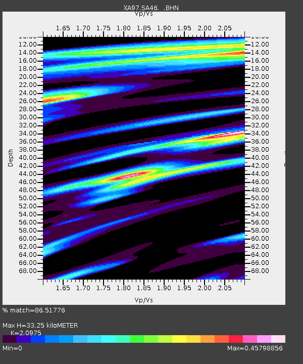
SA46 XA.SA46 - Earthquake Result Viewer
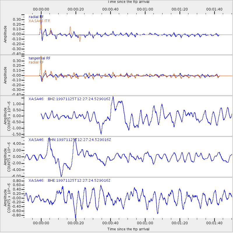
Earthquake location: Minahassa Peninsula, Sulawesi
Earthquake latitude/longitude: 1.2/122.5
Earthquake time(UTC): 1997/11/25 (329) 12:14:33 GMT
Earthquake Depth: 24 km
Earthquake Magnitude: 6.1 MB, 6.8 MS, 7.1 UNKNOWN, 6.7 ME
Earthquake Catalog/Contributor: WHDF/NEIC
Network: XA Anatomy of an Archean Craton, South Africa
Station: SA46 XA.SA46
Lat/Lon: 24.84 S/27.11 E
Elevation: 1037 m
Distance: 95.4 deg
Az: 245.312 deg
Baz: 91.148 deg
Ray Param: 0.04077194
Estimated Moho Depth: 33.25 km
Estimated Crust Vp/Vs: 2.10
Assumed Crust Vp: 6.459 km/s
Estimated Crust Vs: 3.08 km/s
Estimated Crust Poisson's Ratio: 0.35
Radial Match: 86.51776 %
Radial Bump: 400
Transverse Match: 75.867874 %
Transverse Bump: 400
SOD ConfigId: 4480
Insert Time: 2010-02-26 18:16:10.581 +0000
GWidth: 2.5
Max Bumps: 400
Tol: 0.001

Signal To Noise

ChannelStoNSTALTA
XA:SA46: :BHN:19971125T12:27:24.529016Z8.051252.4711153E-63.0692317E-7
XA:SA46: :BHE:19971125T12:27:24.529016Z0.87995571.27093E-71.4443114E-7
XA:SA46: :BHZ:19971125T12:27:24.529016Z4.09381256.4780863E-71.5824091E-7
Arrivals
Ps5.7 SECOND
PpPs16 SECOND
PsPs/PpSs21 SECOND