You are here: Home > Network List > US - United States National Seismic Network Stations List
> Station AMTX Amarillo, Texas, USA > Earthquake Result Viewer
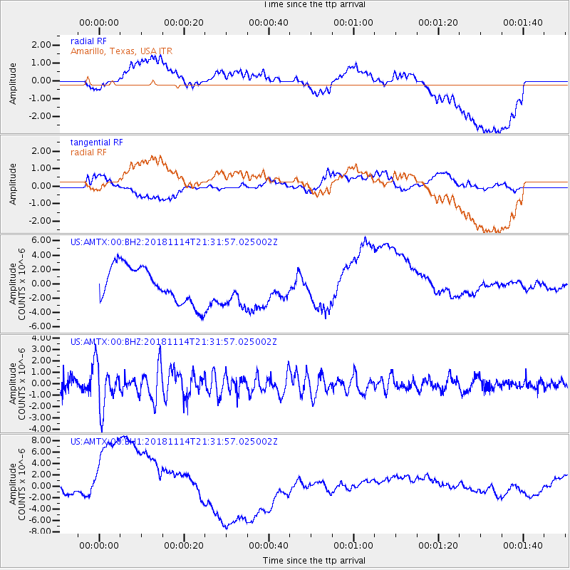
AMTX Amarillo, Texas, USA - Earthquake Result Viewer
*The percent match for this event was below the threshold and hence no stack was calculated.
| Earthquake location: |
Near East Coast Of Kamchatka |
| Earthquake latitude/longitude: |
55.6/162.0 |
| Earthquake time(UTC): |
2018/11/14 (318) 21:21:50 GMT |
| Earthquake Depth: |
50 km |
| Earthquake Magnitude: |
6.1 Mww |
| Earthquake Catalog/Contributor: |
NEIC PDE/us |
|
| Network: |
US United States National Seismic Network |
| Station: |
AMTX Amarillo, Texas, USA |
| Lat/Lon: |
34.53 N/101.41 W |
| Elevation: |
1010 m |
|
| Distance: |
65.7 deg |
| Az: |
64.112 deg |
| Baz: |
321.834 deg |
| Ray Param: |
$rayparam |
*The percent match for this event was below the threshold and hence was not used in the summary stack. |
|
| Radial Match: |
30.480026 % |
| Radial Bump: |
400 |
| Transverse Match: |
25.057579 % |
| Transverse Bump: |
400 |
| SOD ConfigId: |
3165032 |
| Insert Time: |
2018-11-28 21:38:07.862 +0000 |
| GWidth: |
2.5 |
| Max Bumps: |
400 |
| Tol: |
0.001 |
|
Signal To Noise
| Channel | StoN | STA | LTA |
| US:AMTX:00:BHZ:20181114T21:31:57.025002Z | 3.467087 | 1.8742606E-6 | 5.4058654E-7 |
| US:AMTX:00:BH1:20181114T21:31:57.025002Z | 2.384592 | 1.0618436E-5 | 4.4529365E-6 |
| US:AMTX:00:BH2:20181114T21:31:57.025002Z | 1.0589404 | 2.782701E-6 | 2.6278162E-6 |
| Arrivals |
| Ps | |
| PpPs | |
| PsPs/PpSs | |


