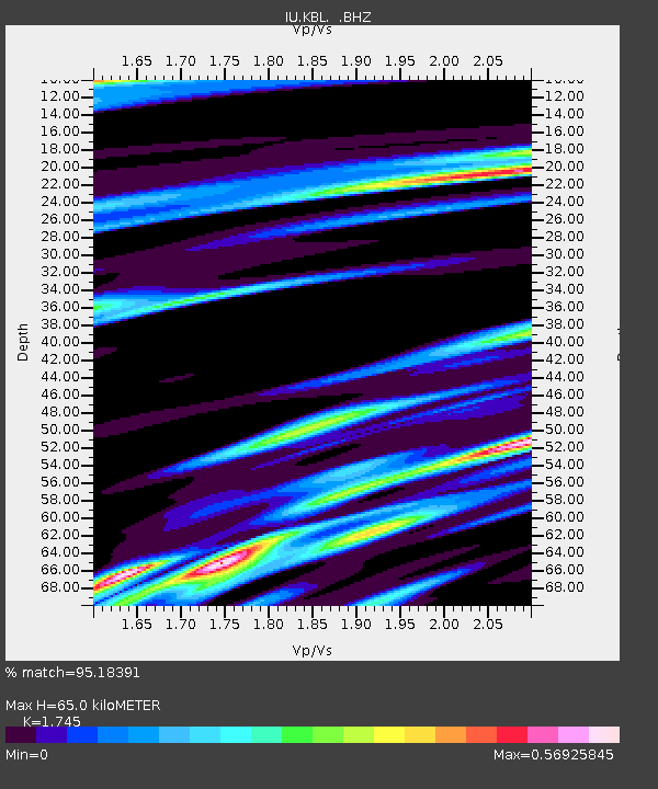
KBL Kabul, Afghanistan - Earthquake Result Viewer

Earthquake location: Southeast Of Ryukyu Islands
Earthquake latitude/longitude: 25.8/129.9
Earthquake time(UTC): 2010/05/26 (146) 08:53:08 GMT
Earthquake Depth: 10 km
Earthquake Magnitude: 6.2 MB, 6.2 MS, 6.5 MW, 6.5 MW
Earthquake Catalog/Contributor: WHDF/NEIC
Network: IU Global Seismograph Network (GSN - IRIS/USGS)
Station: KBL Kabul, Afghanistan
Lat/Lon: 34.54 N/69.04 E
Elevation: 1920 m
Distance: 52.7 deg
Az: 294.932 deg
Baz: 82.088 deg
Ray Param: 0.066594824
Estimated Moho Depth: 65.0 km
Estimated Crust Vp/Vs: 1.75
Assumed Crust Vp: 6.641 km/s
Estimated Crust Vs: 3.806 km/s
Estimated Crust Poisson's Ratio: 0.26
Radial Match: 95.18391 %
Radial Bump: 387
Transverse Match: 92.21642 %
Transverse Bump: 400
SOD ConfigId: 314592
Insert Time: 2010-09-14 06:59:50.829 +0000
GWidth: 2.5
Max Bumps: 400
Tol: 0.001

Signal To Noise

ChannelStoNSTALTA
IU:KBL: :BHZ:20100526T09:01:51.569978Z27.5438211.2352641E-64.484723E-8
IU:KBL: :BHN:20100526T09:01:51.569978Z4.9239061.8052091E-73.6662136E-8
IU:KBL: :BHE:20100526T09:01:51.569978Z11.1355363.9831278E-73.5769517E-8
Arrivals
Ps7.7 SECOND
PpPs25 SECOND
PsPs/PpSs33 SECOND