GNI Garni, Armenia - Earthquake Result Viewer
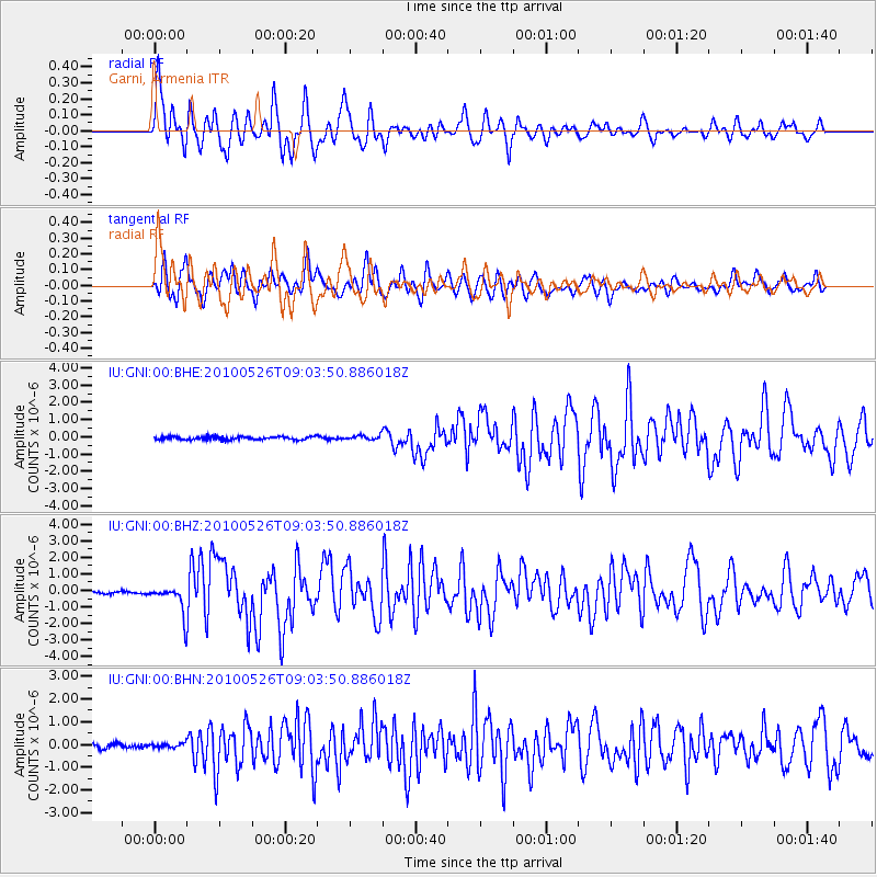
Earthquake location: Southeast Of Ryukyu Islands
Earthquake latitude/longitude: 25.8/129.9
Earthquake time(UTC): 2010/05/26 (146) 08:53:08 GMT
Earthquake Depth: 10 km
Earthquake Magnitude: 6.2 MB, 6.2 MS, 6.5 MW, 6.5 MW
Earthquake Catalog/Contributor: WHDF/NEIC
Network: IU Global Seismograph Network (GSN - IRIS/USGS)
Station: GNI Garni, Armenia
Lat/Lon: 40.15 N/44.74 E
Elevation: 1609 m
Distance: 70.4 deg
Az: 305.823 deg
Baz: 72.515 deg
Ray Param: 0.055011135
Estimated Moho Depth: 30.0 km
Estimated Crust Vp/Vs: 2.10
Assumed Crust Vp: 6.291 km/s
Estimated Crust Vs: 2.999 km/s
Estimated Crust Poisson's Ratio: 0.35
Radial Match: 82.83679 %
Radial Bump: 400
Transverse Match: 69.6034 %
Transverse Bump: 400
SOD ConfigId: 314592
Insert Time: 2010-09-14 06:59:59.843 +0000
GWidth: 2.5
Max Bumps: 400
Tol: 0.001

Signal To Noise

ChannelStoNSTALTA
IU:GNI:00:BHZ:20100526T09:03:50.886018Z9.5389228.4280595E-78.835442E-8
IU:GNI:00:BHN:20100526T09:03:50.886018Z1.11301821.12703745E-71.0125957E-7
IU:GNI:00:BHE:20100526T09:03:50.886018Z1.4577711.3103192E-78.988513E-8
Arrivals
Ps5.4 SECOND
PpPs14 SECOND
PsPs/PpSs20 SECOND