You are here: Home > Network List > US - United States National Seismic Network Stations List
> Station EYMN Ely, Minnesota, USA > Earthquake Result Viewer
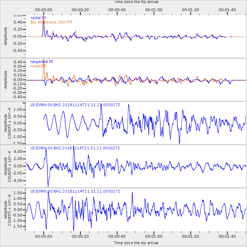
EYMN Ely, Minnesota, USA - Earthquake Result Viewer
*The percent match for this event was below the threshold and hence no stack was calculated.
| Earthquake location: |
Near East Coast Of Kamchatka |
| Earthquake latitude/longitude: |
55.6/162.0 |
| Earthquake time(UTC): |
2018/11/14 (318) 21:21:50 GMT |
| Earthquake Depth: |
50 km |
| Earthquake Magnitude: |
6.1 Mww |
| Earthquake Catalog/Contributor: |
NEIC PDE/us |
|
| Network: |
US United States National Seismic Network |
| Station: |
EYMN Ely, Minnesota, USA |
| Lat/Lon: |
47.95 N/91.50 W |
| Elevation: |
475 m |
|
| Distance: |
59.9 deg |
| Az: |
48.162 deg |
| Baz: |
321.066 deg |
| Ray Param: |
$rayparam |
*The percent match for this event was below the threshold and hence was not used in the summary stack. |
|
| Radial Match: |
79.60882 % |
| Radial Bump: |
400 |
| Transverse Match: |
67.40017 % |
| Transverse Bump: |
400 |
| SOD ConfigId: |
3165032 |
| Insert Time: |
2018-11-28 21:38:33.735 +0000 |
| GWidth: |
2.5 |
| Max Bumps: |
400 |
| Tol: |
0.001 |
|
Signal To Noise
| Channel | StoN | STA | LTA |
| US:EYMN:00:BHZ:20181114T21:31:21.050027Z | 4.425608 | 2.463173E-6 | 5.5657273E-7 |
| US:EYMN:00:BH1:20181114T21:31:21.050027Z | 2.791792 | 8.1154235E-7 | 2.906887E-7 |
| US:EYMN:00:BH2:20181114T21:31:21.050027Z | 1.3140631 | 6.2805145E-7 | 4.7794623E-7 |
| Arrivals |
| Ps | |
| PpPs | |
| PsPs/PpSs | |


