You are here: Home > Network List > US - United States National Seismic Network Stations List
> Station LAO LASA Array, Montana, USA > Earthquake Result Viewer
LAO LASA Array, Montana, USA - Earthquake Result Viewer
*The percent match for this event was below the threshold and hence no stack was calculated.
| Earthquake location: |
Near East Coast Of Kamchatka |
| Earthquake latitude/longitude: |
55.6/162.0 |
| Earthquake time(UTC): |
2018/11/14 (318) 21:21:50 GMT |
| Earthquake Depth: |
50 km |
| Earthquake Magnitude: |
6.1 Mww |
| Earthquake Catalog/Contributor: |
NEIC PDE/us |
|
| Network: |
US United States National Seismic Network |
| Station: |
LAO LASA Array, Montana, USA |
| Lat/Lon: |
46.69 N/106.22 W |
| Elevation: |
902 m |
|
| Distance: |
54.2 deg |
| Az: |
58.063 deg |
| Baz: |
315.647 deg |
| Ray Param: |
$rayparam |
*The percent match for this event was below the threshold and hence was not used in the summary stack. |
|
| Radial Match: |
45.013783 % |
| Radial Bump: |
363 |
| Transverse Match: |
50.64339 % |
| Transverse Bump: |
400 |
| SOD ConfigId: |
3165032 |
| Insert Time: |
2018-11-28 21:38:53.409 +0000 |
| GWidth: |
2.5 |
| Max Bumps: |
400 |
| Tol: |
0.001 |
|
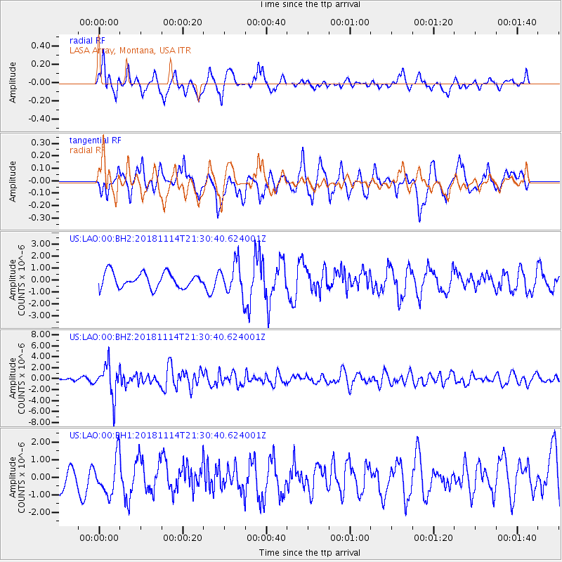
Signal To Noise
| Channel | StoN | STA | LTA |
| US:LAO:00:BHZ:20181114T21:30:40.624001Z | 5.2886195 | 2.9522148E-6 | 5.582203E-7 |
| US:LAO:00:BH1:20181114T21:30:40.624001Z | 0.7261755 | 1.1028621E-6 | 1.5187268E-6 |
| US:LAO:00:BH2:20181114T21:30:40.624001Z | 2.2042708 | 1.3649635E-6 | 6.1923583E-7 |
| Arrivals |
| Ps | |
| PpPs | |
| PsPs/PpSs | |


