You are here: Home > Network List > US - United States National Seismic Network Stations List
> Station LKWY Lake (Yellowstone--Lake), Wyoming, USA > Earthquake Result Viewer
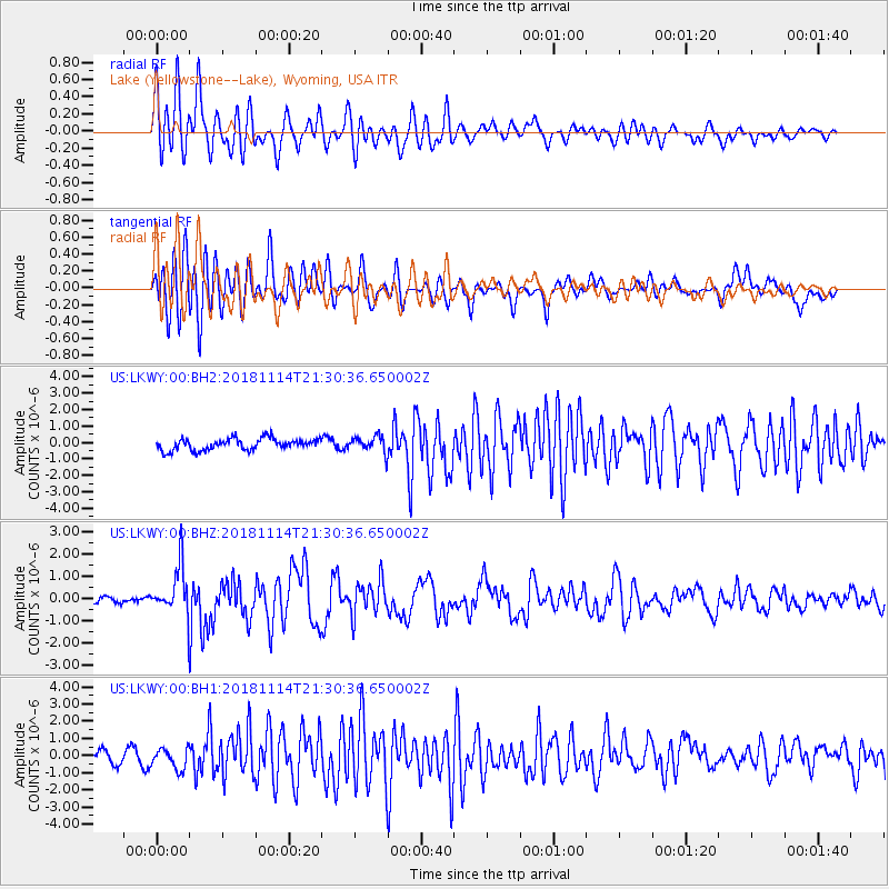
LKWY Lake (Yellowstone--Lake), Wyoming, USA - Earthquake Result Viewer
*The percent match for this event was below the threshold and hence no stack was calculated.
| Earthquake location: |
Near East Coast Of Kamchatka |
| Earthquake latitude/longitude: |
55.6/162.0 |
| Earthquake time(UTC): |
2018/11/14 (318) 21:21:50 GMT |
| Earthquake Depth: |
50 km |
| Earthquake Magnitude: |
6.1 Mww |
| Earthquake Catalog/Contributor: |
NEIC PDE/us |
|
| Network: |
US United States National Seismic Network |
| Station: |
LKWY Lake (Yellowstone--Lake), Wyoming, USA |
| Lat/Lon: |
44.57 N/110.40 W |
| Elevation: |
2424 m |
|
| Distance: |
53.6 deg |
| Az: |
62.491 deg |
| Baz: |
315.28 deg |
| Ray Param: |
$rayparam |
*The percent match for this event was below the threshold and hence was not used in the summary stack. |
|
| Radial Match: |
77.55424 % |
| Radial Bump: |
400 |
| Transverse Match: |
77.24582 % |
| Transverse Bump: |
400 |
| SOD ConfigId: |
3165032 |
| Insert Time: |
2018-11-28 21:38:56.556 +0000 |
| GWidth: |
2.5 |
| Max Bumps: |
400 |
| Tol: |
0.001 |
|
Signal To Noise
| Channel | StoN | STA | LTA |
| US:LKWY:00:BHZ:20181114T21:30:36.650002Z | 5.9239464 | 1.0919509E-6 | 1.8432829E-7 |
| US:LKWY:00:BH1:20181114T21:30:36.650002Z | 1.5899915 | 6.259034E-7 | 3.9365207E-7 |
| US:LKWY:00:BH2:20181114T21:30:36.650002Z | 1.4131732 | 4.9514574E-7 | 3.5037866E-7 |
| Arrivals |
| Ps | |
| PpPs | |
| PsPs/PpSs | |


