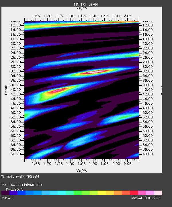
TRI Trieste, Italy - Earthquake Result Viewer
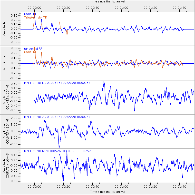
Earthquake location: Southeast Of Ryukyu Islands
Earthquake latitude/longitude: 25.8/129.9
Earthquake time(UTC): 2010/05/26 (146) 08:53:08 GMT
Earthquake Depth: 10 km
Earthquake Magnitude: 6.2 MB, 6.2 MS, 6.5 MW, 6.5 MW
Earthquake Catalog/Contributor: WHDF/NEIC
Network: MN MEDNET Project
Station: TRI Trieste, Italy
Lat/Lon: 45.71 N/13.76 E
Elevation: 161 m
Distance: 88.3 deg
Az: 321.016 deg
Baz: 54.049 deg
Ray Param: 0.042694174
Estimated Moho Depth: 32.0 km
Estimated Crust Vp/Vs: 1.91
Assumed Crust Vp: 6.207 km/s
Estimated Crust Vs: 3.254 km/s
Estimated Crust Poisson's Ratio: 0.31
Radial Match: 87.792984 %
Radial Bump: 400
Transverse Match: 79.03132 %
Transverse Bump: 400
SOD ConfigId: 314592
Insert Time: 2010-09-14 07:02:28.937 +0000
GWidth: 2.5
Max Bumps: 400
Tol: 0.001

Signal To Noise

ChannelStoNSTALTA
MN:TRI: :BHZ:20100526T09:05:28.068025Z4.24761065.102785E-71.2013308E-7
MN:TRI: :BHN:20100526T09:05:28.068025Z1.75566771.3196438E-77.5164785E-8
MN:TRI: :BHE:20100526T09:05:28.068025Z1.33690631.3610288E-71.0180435E-7
Arrivals
Ps4.8 SECOND
PpPs15 SECOND
PsPs/PpSs19 SECOND