You are here: Home > Network List > US - United States National Seismic Network Stations List
> Station MSO Missoula, Montana, USA > Earthquake Result Viewer
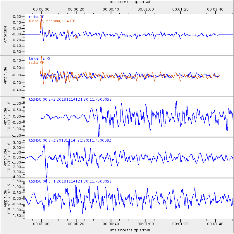
MSO Missoula, Montana, USA - Earthquake Result Viewer
*The percent match for this event was below the threshold and hence no stack was calculated.
| Earthquake location: |
Near East Coast Of Kamchatka |
| Earthquake latitude/longitude: |
55.6/162.0 |
| Earthquake time(UTC): |
2018/11/14 (318) 21:21:50 GMT |
| Earthquake Depth: |
50 km |
| Earthquake Magnitude: |
6.1 Mww |
| Earthquake Catalog/Contributor: |
NEIC PDE/us |
|
| Network: |
US United States National Seismic Network |
| Station: |
MSO Missoula, Montana, USA |
| Lat/Lon: |
46.83 N/113.94 W |
| Elevation: |
1264 m |
|
| Distance: |
50.3 deg |
| Az: |
62.617 deg |
| Baz: |
312.831 deg |
| Ray Param: |
$rayparam |
*The percent match for this event was below the threshold and hence was not used in the summary stack. |
|
| Radial Match: |
77.99897 % |
| Radial Bump: |
400 |
| Transverse Match: |
69.728806 % |
| Transverse Bump: |
400 |
| SOD ConfigId: |
3165032 |
| Insert Time: |
2018-11-28 21:39:03.894 +0000 |
| GWidth: |
2.5 |
| Max Bumps: |
400 |
| Tol: |
0.001 |
|
Signal To Noise
| Channel | StoN | STA | LTA |
| US:MSO:00:BHZ:20181114T21:30:11.750009Z | 7.756815 | 1.7835794E-6 | 2.2993707E-7 |
| US:MSO:00:BH1:20181114T21:30:11.750009Z | 3.4176195 | 7.059465E-7 | 2.0656088E-7 |
| US:MSO:00:BH2:20181114T21:30:11.750009Z | 6.217231 | 6.637376E-7 | 1.0675775E-7 |
| Arrivals |
| Ps | |
| PpPs | |
| PsPs/PpSs | |


