You are here: Home > Network List > MN - MEDNET Project Stations List
> Station TIP Timpagrande, Italy > Earthquake Result Viewer
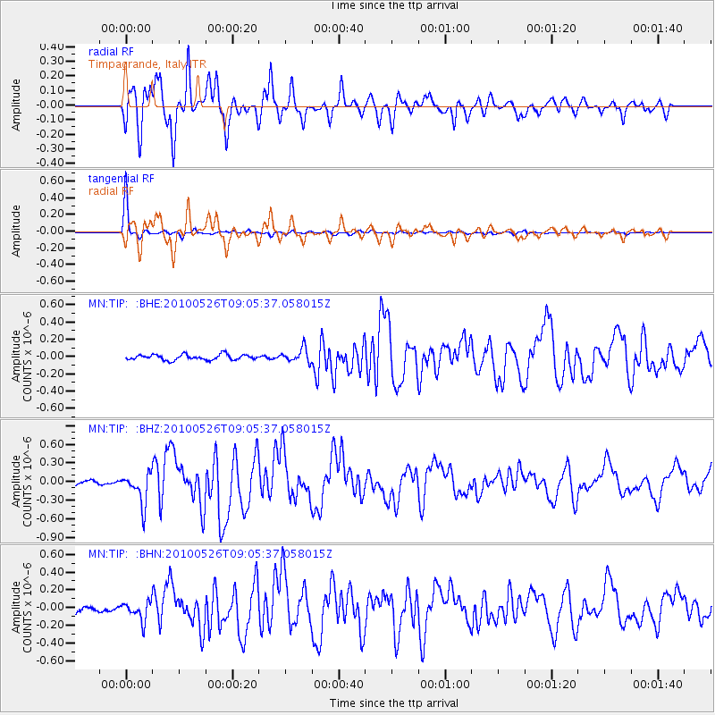
TIP Timpagrande, Italy - Earthquake Result Viewer
*The percent match for this event was below the threshold and hence no stack was calculated.
| Earthquake location: |
Southeast Of Ryukyu Islands |
| Earthquake latitude/longitude: |
25.8/129.9 |
| Earthquake time(UTC): |
2010/05/26 (146) 08:53:08 GMT |
| Earthquake Depth: |
10 km |
| Earthquake Magnitude: |
6.2 MB, 6.2 MS, 6.5 MW, 6.5 MW |
| Earthquake Catalog/Contributor: |
WHDF/NEIC |
|
| Network: |
MN MEDNET Project |
| Station: |
TIP Timpagrande, Italy |
| Lat/Lon: |
39.18 N/16.76 E |
| Elevation: |
789 m |
|
| Distance: |
90.2 deg |
| Az: |
314.4 deg |
| Baz: |
55.98 deg |
| Ray Param: |
$rayparam |
*The percent match for this event was below the threshold and hence was not used in the summary stack. |
|
| Radial Match: |
86.18564 % |
| Radial Bump: |
400 |
| Transverse Match: |
98.97556 % |
| Transverse Bump: |
163 |
| SOD ConfigId: |
314592 |
| Insert Time: |
2010-09-14 07:02:37.275 +0000 |
| GWidth: |
2.5 |
| Max Bumps: |
400 |
| Tol: |
0.001 |
|
Signal To Noise
| Channel | StoN | STA | LTA |
| MN:TIP: :BHZ:20100526T09:05:37.058015Z | 8.995416 | 2.5310408E-7 | 2.813701E-8 |
| MN:TIP: :BHN:20100526T09:05:37.058015Z | 3.2552793 | 1.0462462E-7 | 3.2139983E-8 |
| MN:TIP: :BHE:20100526T09:05:37.058015Z | 2.570893 | 8.064281E-8 | 3.1367627E-8 |
| Arrivals |
| Ps | |
| PpPs | |
| PsPs/PpSs | |


