You are here: Home > Network List > TX - Texas Seismological Network Stations List
> Station ET01 Chireno > Earthquake Result Viewer
ET01 Chireno - Earthquake Result Viewer
| Earthquake location: |
Tonga Islands Region |
| Earthquake latitude/longitude: |
-23.5/-175.6 |
| Earthquake time(UTC): |
2023/07/02 (183) 02:41:17 GMT |
| Earthquake Depth: |
10 km |
| Earthquake Magnitude: |
5.6 Mww |
| Earthquake Catalog/Contributor: |
NEIC PDE/us |
|
| Network: |
TX Texas Seismological Network |
| Station: |
ET01 Chireno |
| Lat/Lon: |
31.46 N/94.37 W |
| Elevation: |
127 m |
|
| Distance: |
95.0 deg |
| Az: |
57.964 deg |
| Baz: |
245.569 deg |
| Ray Param: |
0.040913522 |
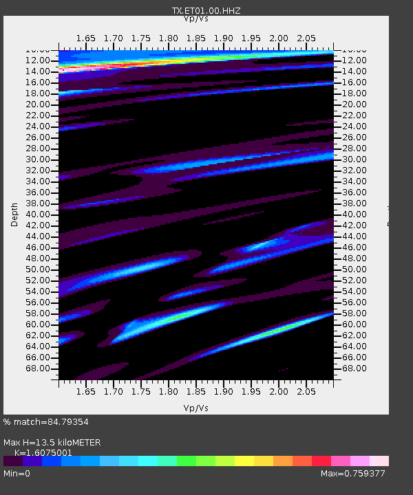
| Estimated Moho Depth: |
13.5 km |
| Estimated Crust Vp/Vs: |
1.61 |
| Assumed Crust Vp: |
5.738 km/s |
| Estimated Crust Vs: |
3.57 km/s |
| Estimated Crust Poisson's Ratio: |
0.18 |
|
| Radial Match: |
84.79354 % |
| Radial Bump: |
223 |
| Transverse Match: |
75.516525 % |
| Transverse Bump: |
311 |
| SOD ConfigId: |
30536071 |
| Insert Time: |
2023-07-16 03:03:01.448 +0000 |
| GWidth: |
2.5 |
| Max Bumps: |
400 |
| Tol: |
0.001 |
|

Signal To Noise
| Channel | StoN | STA | LTA |
| TX:ET01:00:HHZ:20230702T02:54:08.710004Z | 0.4897609 | 1.737863E-7 | 3.5483907E-7 |
| TX:ET01:00:HH1:20230702T02:54:08.710004Z | 0.7417774 | 2.807902E-7 | 3.78537E-7 |
| TX:ET01:00:HH2:20230702T02:54:08.710004Z | 0.5646658 | 2.0737099E-7 | 3.6724552E-7 |
| Arrivals |
| Ps | 1.5 SECOND |
| PpPs | 6.0 SECOND |
| PsPs/PpSs | 7.5 SECOND |


