You are here: Home > Network List > UW - Pacific Northwest Regional Seismic Network Stations List
> Station HOOD Mt Hood Meadows, OR CREST BB SMO > Earthquake Result Viewer
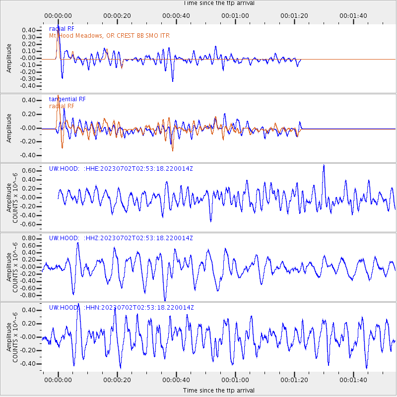
HOOD Mt Hood Meadows, OR CREST BB SMO - Earthquake Result Viewer
*The percent match for this event was below the threshold and hence no stack was calculated.
| Earthquake location: |
Tonga Islands Region |
| Earthquake latitude/longitude: |
-23.5/-175.6 |
| Earthquake time(UTC): |
2023/07/02 (183) 02:41:17 GMT |
| Earthquake Depth: |
10 km |
| Earthquake Magnitude: |
5.6 Mww |
| Earthquake Catalog/Contributor: |
NEIC PDE/us |
|
| Network: |
UW Pacific Northwest Regional Seismic Network |
| Station: |
HOOD Mt Hood Meadows, OR CREST BB SMO |
| Lat/Lon: |
45.32 N/121.65 W |
| Elevation: |
1520 m |
|
| Distance: |
84.3 deg |
| Az: |
34.973 deg |
| Baz: |
228.214 deg |
| Ray Param: |
$rayparam |
*The percent match for this event was below the threshold and hence was not used in the summary stack. |
|
| Radial Match: |
74.91495 % |
| Radial Bump: |
400 |
| Transverse Match: |
61.22115 % |
| Transverse Bump: |
400 |
| SOD ConfigId: |
30536071 |
| Insert Time: |
2023-07-16 03:05:57.822 +0000 |
| GWidth: |
2.5 |
| Max Bumps: |
400 |
| Tol: |
0.001 |
|
Signal To Noise
| Channel | StoN | STA | LTA |
| UW:HOOD: :HHZ:20230702T02:53:18.220014Z | 1.6407399 | 1.5484001E-7 | 9.437206E-8 |
| UW:HOOD: :HHN:20230702T02:53:18.220014Z | 0.90459454 | 8.334275E-8 | 9.2132716E-8 |
| UW:HOOD: :HHE:20230702T02:53:18.220014Z | 0.6873629 | 9.939872E-8 | 1.4460879E-7 |
| Arrivals |
| Ps | |
| PpPs | |
| PsPs/PpSs | |


