You are here: Home > Network List > UW - Pacific Northwest Regional Seismic Network Stations List
> Station SKOKO Rock Peak, WA, USA > Earthquake Result Viewer
SKOKO Rock Peak, WA, USA - Earthquake Result Viewer
| Earthquake location: |
Tonga Islands Region |
| Earthquake latitude/longitude: |
-23.5/-175.6 |
| Earthquake time(UTC): |
2023/07/02 (183) 02:41:17 GMT |
| Earthquake Depth: |
10 km |
| Earthquake Magnitude: |
5.6 Mww |
| Earthquake Catalog/Contributor: |
NEIC PDE/us |
|
| Network: |
UW Pacific Northwest Regional Seismic Network |
| Station: |
SKOKO Rock Peak, WA, USA |
| Lat/Lon: |
47.41 N/123.37 W |
| Elevation: |
950 m |
|
| Distance: |
84.8 deg |
| Az: |
32.622 deg |
| Baz: |
226.755 deg |
| Ray Param: |
0.04521763 |
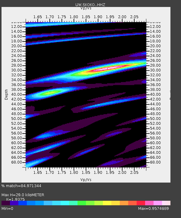
| Estimated Moho Depth: |
29.0 km |
| Estimated Crust Vp/Vs: |
1.94 |
| Assumed Crust Vp: |
6.566 km/s |
| Estimated Crust Vs: |
3.389 km/s |
| Estimated Crust Poisson's Ratio: |
0.32 |
|
| Radial Match: |
84.971344 % |
| Radial Bump: |
400 |
| Transverse Match: |
78.747665 % |
| Transverse Bump: |
353 |
| SOD ConfigId: |
30536071 |
| Insert Time: |
2023-07-16 03:06:50.920 +0000 |
| GWidth: |
2.5 |
| Max Bumps: |
400 |
| Tol: |
0.001 |
|

Signal To Noise
| Channel | StoN | STA | LTA |
| UW:SKOKO: :HHZ:20230702T02:53:20.910017Z | 3.0285852 | 1.5346119E-7 | 5.067092E-8 |
| UW:SKOKO: :HHN:20230702T02:53:20.910017Z | 1.1463395 | 1.12239796E-7 | 9.7911474E-8 |
| UW:SKOKO: :HHE:20230702T02:53:20.910017Z | 1.5740012 | 1.05157746E-7 | 6.6809186E-8 |
| Arrivals |
| Ps | 4.2 SECOND |
| PpPs | 13 SECOND |
| PsPs/PpSs | 17 SECOND |


