You are here: Home > Network List > 1E - GSC-BCOGC Induced Seismicity Study Stations List
> Station MONT7 Z > Earthquake Result Viewer
MONT7 Z - Earthquake Result Viewer
| Earthquake location: |
Tonga Islands |
| Earthquake latitude/longitude: |
-17.9/-174.7 |
| Earthquake time(UTC): |
2023/07/02 (183) 10:27:45 GMT |
| Earthquake Depth: |
247 km |
| Earthquake Magnitude: |
6.7 Mi |
| Earthquake Catalog/Contributor: |
NEIC PDE/at |
|
| Network: |
1E GSC-BCOGC Induced Seismicity Study |
| Station: |
MONT7 Z |
| Lat/Lon: |
56.31 N/122.03 W |
| Elevation: |
797 m |
|
| Distance: |
86.1 deg |
| Az: |
26.37 deg |
| Baz: |
229.367 deg |
| Ray Param: |
0.043703362 |
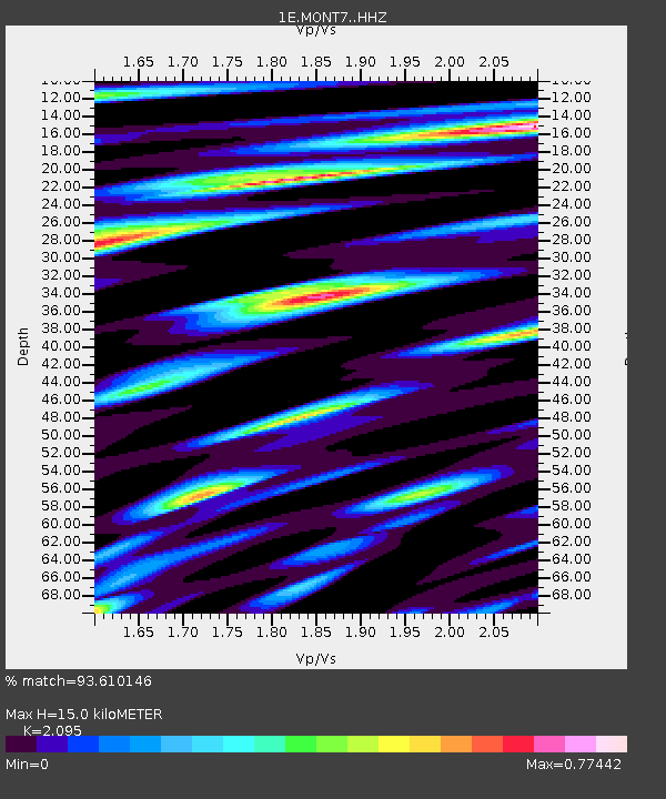
| Estimated Moho Depth: |
15.0 km |
| Estimated Crust Vp/Vs: |
2.10 |
| Assumed Crust Vp: |
6.232 km/s |
| Estimated Crust Vs: |
2.975 km/s |
| Estimated Crust Poisson's Ratio: |
0.35 |
|
| Radial Match: |
93.610146 % |
| Radial Bump: |
400 |
| Transverse Match: |
85.71028 % |
| Transverse Bump: |
400 |
| SOD ConfigId: |
30536071 |
| Insert Time: |
2023-07-16 10:29:31.153 +0000 |
| GWidth: |
2.5 |
| Max Bumps: |
400 |
| Tol: |
0.001 |
|

Signal To Noise
| Channel | StoN | STA | LTA |
| 1E:MONT7: :HHZ:20230702T10:39:26.700012Z | 32.277603 | 2.9001376E-6 | 8.984985E-8 |
| 1E:MONT7: :HHN:20230702T10:39:26.700012Z | 2.725398 | 4.938355E-7 | 1.8119758E-7 |
| 1E:MONT7: :HHE:20230702T10:39:26.700012Z | 2.7282 | 5.083747E-7 | 1.8634071E-7 |
| Arrivals |
| Ps | 2.7 SECOND |
| PpPs | 7.3 SECOND |
| PsPs/PpSs | 10 SECOND |


