You are here: Home > Network List > 1E - GSC-BCOGC Induced Seismicity Study Stations List
> Station MONTE Z > Earthquake Result Viewer
MONTE Z - Earthquake Result Viewer
| Earthquake location: |
Tonga Islands |
| Earthquake latitude/longitude: |
-17.9/-174.7 |
| Earthquake time(UTC): |
2023/07/02 (183) 10:27:45 GMT |
| Earthquake Depth: |
247 km |
| Earthquake Magnitude: |
6.7 Mi |
| Earthquake Catalog/Contributor: |
NEIC PDE/at |
|
| Network: |
1E GSC-BCOGC Induced Seismicity Study |
| Station: |
MONTE Z |
| Lat/Lon: |
57.21 N/122.17 W |
| Elevation: |
0.0 m |
|
| Distance: |
86.6 deg |
| Az: |
25.629 deg |
| Baz: |
229.2 deg |
| Ray Param: |
0.04332218 |
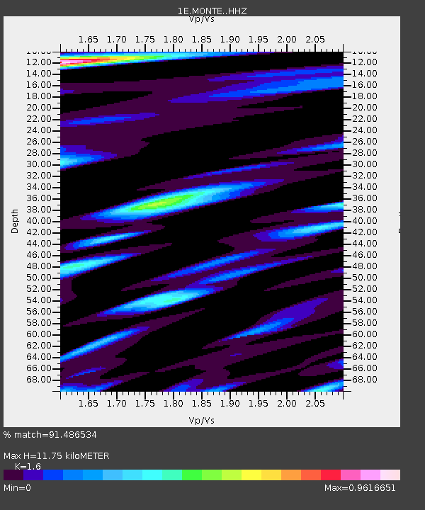
| Estimated Moho Depth: |
11.75 km |
| Estimated Crust Vp/Vs: |
1.60 |
| Assumed Crust Vp: |
6.232 km/s |
| Estimated Crust Vs: |
3.895 km/s |
| Estimated Crust Poisson's Ratio: |
0.18 |
|
| Radial Match: |
91.486534 % |
| Radial Bump: |
400 |
| Transverse Match: |
87.657 % |
| Transverse Bump: |
400 |
| SOD ConfigId: |
30536071 |
| Insert Time: |
2023-07-16 10:29:41.895 +0000 |
| GWidth: |
2.5 |
| Max Bumps: |
400 |
| Tol: |
0.001 |
|

Signal To Noise
| Channel | StoN | STA | LTA |
| 1E:MONTE: :HHZ:20230702T10:39:29.27002Z | 36.787407 | 3.3236836E-6 | 9.034841E-8 |
| 1E:MONTE: :HHN:20230702T10:39:29.27002Z | 4.459477 | 3.328153E-7 | 7.463102E-8 |
| 1E:MONTE: :HHE:20230702T10:39:29.27002Z | 9.5584 | 7.3208895E-7 | 7.659116E-8 |
| Arrivals |
| Ps | 1.2 SECOND |
| PpPs | 4.8 SECOND |
| PsPs/PpSs | 5.9 SECOND |


