You are here: Home > Network List > AK - Alaska Regional Network Stations List
> Station KLU Klutina Pass, Alaska, USA > Earthquake Result Viewer
KLU Klutina Pass, Alaska, USA - Earthquake Result Viewer
| Earthquake location: |
Tonga Islands |
| Earthquake latitude/longitude: |
-17.9/-174.7 |
| Earthquake time(UTC): |
2023/07/02 (183) 10:27:45 GMT |
| Earthquake Depth: |
247 km |
| Earthquake Magnitude: |
6.7 Mi |
| Earthquake Catalog/Contributor: |
NEIC PDE/at |
|
| Network: |
AK Alaska Regional Network |
| Station: |
KLU Klutina Pass, Alaska, USA |
| Lat/Lon: |
61.49 N/145.92 W |
| Elevation: |
1021 m |
|
| Distance: |
82.4 deg |
| Az: |
13.475 deg |
| Baz: |
207.548 deg |
| Ray Param: |
0.04630334 |
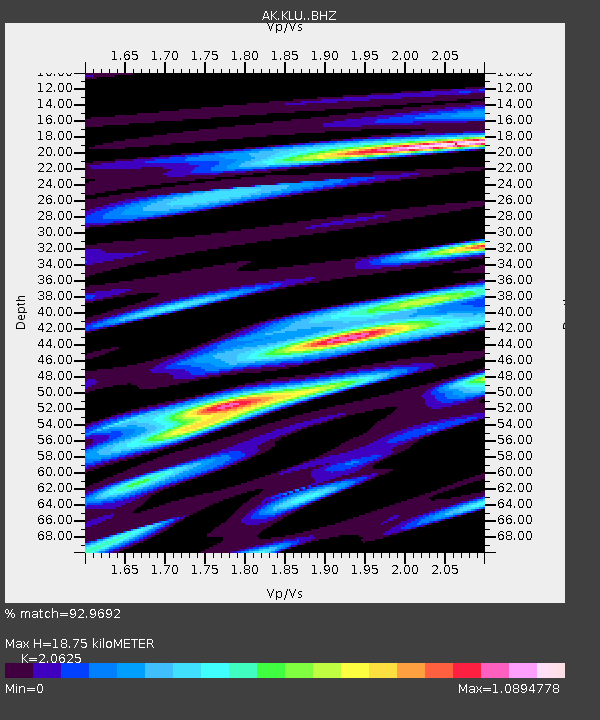
| Estimated Moho Depth: |
18.75 km |
| Estimated Crust Vp/Vs: |
2.06 |
| Assumed Crust Vp: |
6.566 km/s |
| Estimated Crust Vs: |
3.184 km/s |
| Estimated Crust Poisson's Ratio: |
0.35 |
|
| Radial Match: |
92.9692 % |
| Radial Bump: |
400 |
| Transverse Match: |
82.577225 % |
| Transverse Bump: |
400 |
| SOD ConfigId: |
30536071 |
| Insert Time: |
2023-07-16 10:32:44.677 +0000 |
| GWidth: |
2.5 |
| Max Bumps: |
400 |
| Tol: |
0.001 |
|

Signal To Noise
| Channel | StoN | STA | LTA |
| AK:KLU: :BHZ:20230702T10:39:08.228027Z | 37.703682 | 3.74773E-6 | 9.939958E-8 |
| AK:KLU: :BHN:20230702T10:39:08.228027Z | 20.180098 | 1.2742045E-6 | 6.314164E-8 |
| AK:KLU: :BHE:20230702T10:39:08.228027Z | 16.617851 | 8.525671E-7 | 5.1304294E-8 |
| Arrivals |
| Ps | 3.1 SECOND |
| PpPs | 8.5 SECOND |
| PsPs/PpSs | 12 SECOND |


