You are here: Home > Network List > AK - Alaska Regional Network Stations List
> Station MDM Murphy Dome > Earthquake Result Viewer
MDM Murphy Dome - Earthquake Result Viewer
| Earthquake location: |
Tonga Islands |
| Earthquake latitude/longitude: |
-17.9/-174.7 |
| Earthquake time(UTC): |
2023/07/02 (183) 10:27:45 GMT |
| Earthquake Depth: |
247 km |
| Earthquake Magnitude: |
6.7 Mi |
| Earthquake Catalog/Contributor: |
NEIC PDE/at |
|
| Network: |
AK Alaska Regional Network |
| Station: |
MDM Murphy Dome |
| Lat/Lon: |
64.96 N/148.23 W |
| Elevation: |
634 m |
|
| Distance: |
85.0 deg |
| Az: |
10.977 deg |
| Baz: |
205.216 deg |
| Ray Param: |
0.044444524 |
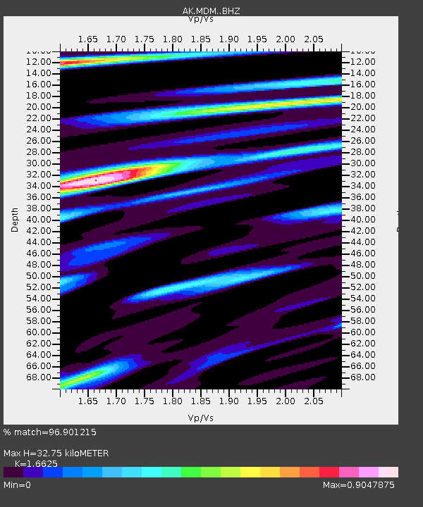
| Estimated Moho Depth: |
32.75 km |
| Estimated Crust Vp/Vs: |
1.66 |
| Assumed Crust Vp: |
6.566 km/s |
| Estimated Crust Vs: |
3.95 km/s |
| Estimated Crust Poisson's Ratio: |
0.22 |
|
| Radial Match: |
96.901215 % |
| Radial Bump: |
254 |
| Transverse Match: |
95.90844 % |
| Transverse Bump: |
366 |
| SOD ConfigId: |
30536071 |
| Insert Time: |
2023-07-16 10:33:08.954 +0000 |
| GWidth: |
2.5 |
| Max Bumps: |
400 |
| Tol: |
0.001 |
|

Signal To Noise
| Channel | StoN | STA | LTA |
| AK:MDM: :BHZ:20230702T10:39:21.607971Z | 93.517494 | 5.7637503E-6 | 6.163286E-8 |
| AK:MDM: :BHN:20230702T10:39:21.607971Z | 34.810204 | 1.623697E-6 | 4.6644285E-8 |
| AK:MDM: :BHE:20230702T10:39:21.607971Z | 29.372885 | 9.1620456E-7 | 3.119219E-8 |
| Arrivals |
| Ps | 3.4 SECOND |
| PpPs | 13 SECOND |
| PsPs/PpSs | 16 SECOND |


