You are here: Home > Network List > TA - USArray Transportable Network (new EarthScope stations) Stations List
> Station O22A Kremmling, CO, USA > Earthquake Result Viewer
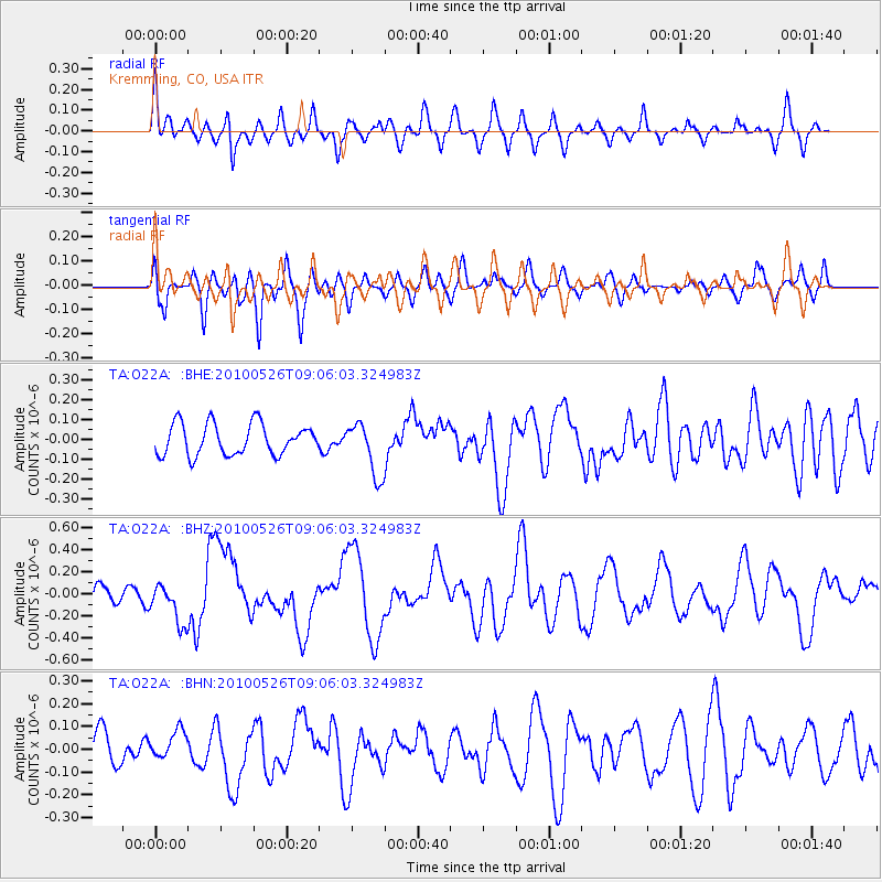
O22A Kremmling, CO, USA - Earthquake Result Viewer
*The percent match for this event was below the threshold and hence no stack was calculated.
| Earthquake location: |
Southeast Of Ryukyu Islands |
| Earthquake latitude/longitude: |
25.8/129.9 |
| Earthquake time(UTC): |
2010/05/26 (146) 08:53:08 GMT |
| Earthquake Depth: |
10 km |
| Earthquake Magnitude: |
6.2 MB, 6.2 MS, 6.5 MW, 6.5 MW |
| Earthquake Catalog/Contributor: |
WHDF/NEIC |
|
| Network: |
TA USArray Transportable Network (new EarthScope stations) |
| Station: |
O22A Kremmling, CO, USA |
| Lat/Lon: |
40.16 N/106.55 W |
| Elevation: |
2747 m |
|
| Distance: |
96.0 deg |
| Az: |
39.975 deg |
| Baz: |
310.898 deg |
| Ray Param: |
$rayparam |
*The percent match for this event was below the threshold and hence was not used in the summary stack. |
|
| Radial Match: |
60.612953 % |
| Radial Bump: |
400 |
| Transverse Match: |
60.022614 % |
| Transverse Bump: |
400 |
| SOD ConfigId: |
314592 |
| Insert Time: |
2010-09-14 07:05:27.861 +0000 |
| GWidth: |
2.5 |
| Max Bumps: |
400 |
| Tol: |
0.001 |
|
Signal To Noise
| Channel | StoN | STA | LTA |
| TA:O22A: :BHZ:20100526T09:06:03.324983Z | 2.4562588 | 1.8199061E-7 | 7.409261E-8 |
| TA:O22A: :BHN:20100526T09:06:03.324983Z | 0.87364185 | 6.617828E-8 | 7.5749895E-8 |
| TA:O22A: :BHE:20100526T09:06:03.324983Z | 1.7270261 | 1.3459947E-7 | 7.7937145E-8 |
| Arrivals |
| Ps | |
| PpPs | |
| PsPs/PpSs | |


