You are here: Home > Network List > TA - USArray Transportable Network (new EarthScope stations) Stations List
> Station Q24A Divide, CO, USA > Earthquake Result Viewer
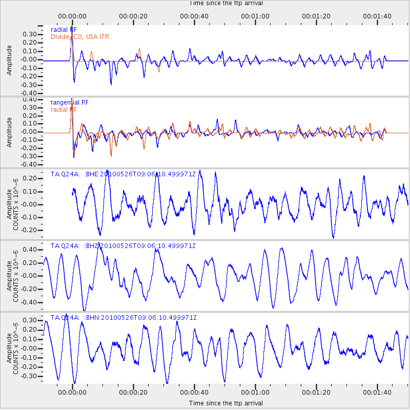
Q24A Divide, CO, USA - Earthquake Result Viewer
*The percent match for this event was below the threshold and hence no stack was calculated.
| Earthquake location: |
Southeast Of Ryukyu Islands |
| Earthquake latitude/longitude: |
25.8/129.9 |
| Earthquake time(UTC): |
2010/05/26 (146) 08:53:08 GMT |
| Earthquake Depth: |
10 km |
| Earthquake Magnitude: |
6.2 MB, 6.2 MS, 6.5 MW, 6.5 MW |
| Earthquake Catalog/Contributor: |
WHDF/NEIC |
|
| Network: |
TA USArray Transportable Network (new EarthScope stations) |
| Station: |
Q24A Divide, CO, USA |
| Lat/Lon: |
38.96 N/105.15 W |
| Elevation: |
2775 m |
|
| Distance: |
97.6 deg |
| Az: |
40.16 deg |
| Baz: |
311.763 deg |
| Ray Param: |
$rayparam |
*The percent match for this event was below the threshold and hence was not used in the summary stack. |
|
| Radial Match: |
40.87373 % |
| Radial Bump: |
400 |
| Transverse Match: |
62.13774 % |
| Transverse Bump: |
400 |
| SOD ConfigId: |
314592 |
| Insert Time: |
2010-09-14 07:05:29.821 +0000 |
| GWidth: |
2.5 |
| Max Bumps: |
400 |
| Tol: |
0.001 |
|
Signal To Noise
| Channel | StoN | STA | LTA |
| TA:Q24A: :BHZ:20100526T09:06:10.499971Z | 2.189491 | 3.026784E-7 | 1.3824143E-7 |
| TA:Q24A: :BHN:20100526T09:06:10.499971Z | 1.2235808 | 2.2274993E-7 | 1.8204759E-7 |
| TA:Q24A: :BHE:20100526T09:06:10.499971Z | 0.7973361 | 8.3985455E-8 | 1.0533256E-7 |
| Arrivals |
| Ps | |
| PpPs | |
| PsPs/PpSs | |


