You are here: Home > Network List > AK - Alaska Regional Network Stations List
> Station PS10 TAPS Pump Station 10, AK, USA > Earthquake Result Viewer
PS10 TAPS Pump Station 10, AK, USA - Earthquake Result Viewer
| Earthquake location: |
Tonga Islands |
| Earthquake latitude/longitude: |
-17.9/-174.7 |
| Earthquake time(UTC): |
2023/07/02 (183) 10:27:45 GMT |
| Earthquake Depth: |
247 km |
| Earthquake Magnitude: |
6.7 Mi |
| Earthquake Catalog/Contributor: |
NEIC PDE/at |
|
| Network: |
AK Alaska Regional Network |
| Station: |
PS10 TAPS Pump Station 10, AK, USA |
| Lat/Lon: |
63.42 N/145.77 W |
| Elevation: |
738 m |
|
| Distance: |
84.1 deg |
| Az: |
12.635 deg |
| Baz: |
207.584 deg |
| Ray Param: |
0.045081668 |
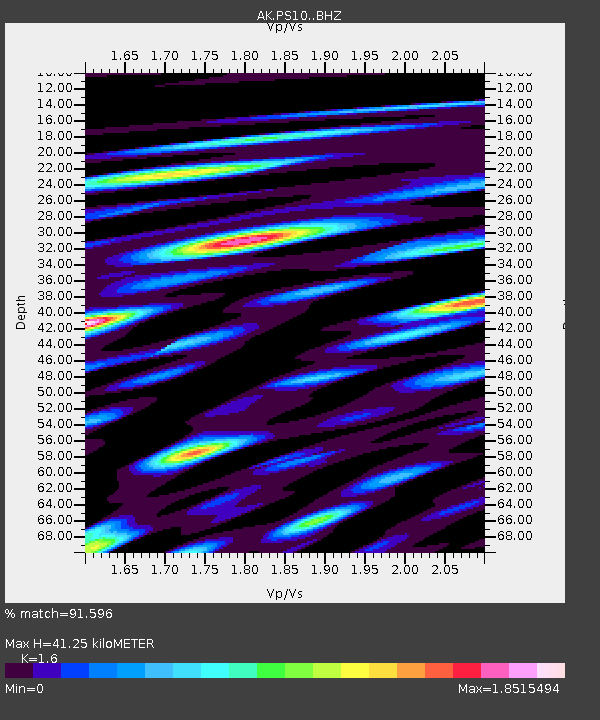
| Estimated Moho Depth: |
41.25 km |
| Estimated Crust Vp/Vs: |
1.60 |
| Assumed Crust Vp: |
6.566 km/s |
| Estimated Crust Vs: |
4.104 km/s |
| Estimated Crust Poisson's Ratio: |
0.18 |
|
| Radial Match: |
91.596 % |
| Radial Bump: |
400 |
| Transverse Match: |
86.76747 % |
| Transverse Bump: |
400 |
| SOD ConfigId: |
30536071 |
| Insert Time: |
2023-07-16 10:33:49.250 +0000 |
| GWidth: |
2.5 |
| Max Bumps: |
400 |
| Tol: |
0.001 |
|

Signal To Noise
| Channel | StoN | STA | LTA |
| AK:PS10: :BHZ:20230702T10:39:17.107971Z | 47.69483 | 5.140396E-6 | 1.07776785E-7 |
| AK:PS10: :BHN:20230702T10:39:17.107971Z | 25.297724 | 3.23525E-6 | 1.27887E-7 |
| AK:PS10: :BHE:20230702T10:39:17.107971Z | 13.103324 | 1.4407628E-6 | 1.09954E-7 |
| Arrivals |
| Ps | 3.9 SECOND |
| PpPs | 16 SECOND |
| PsPs/PpSs | 20 SECOND |


